
Make a donation
Tabasco topographic map
Click on the map to display elevation.
Make a donation
Tabasco
The environment of the state consists of extensive low-lying floodplains, mountains and valleys. Most of the territory is covered with tropical rainforest and wetlands. There are also areas with savanna, beaches and mangrove forests. Much of the rainforest has suffered degradation due to over-logging and conversion of territory into farmland. The east is formed of low humid plains formed by sediment deposited by a number of rivers. In the Chontalpa zone and in parts of the municipalities of Centla and Jonuta, there are swampy depressions extremely vulnerable to flooding from both riverflow and from excessive rainfall. In the south there are some elevations which are part of the central mesa of Chiapas. The most important of these is El Madrigal, La Campana, La Corona, Pomaná, Coconá, Mono Pelado and El Tortuguero. However, most hills in the state do not exceed 30 metres (98 ft) above sea level.
Make a donation
About this map
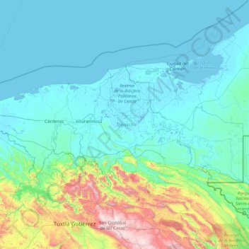
Name: Tabasco topographic map, elevation, terrain.
Location: Tabasco, Mexico (17.25087 -94.12997 18.65043 -90.98733)
Average elevation: 290 m
Minimum elevation: -4 m
Maximum elevation: 2,747 m
Make a donation
Other topographic maps
Click on a map to view its topography, its elevation and its terrain.
San Miguel el Alto
Mexico > Jalisco > San Miguel el Alto > San Miguel el Alto
Average elevation: 1,887 m
Atotonilco El Alto
Mexico > Jalisco > Atotonilco el Alto > Atotonilco El Alto
Average elevation: 1,712 m
Make a donation
Make a donation
Jilotlan de los Dolores
Mexico > Jalisco > Jilotlán de los Dolores > Jilotlan de los Dolores
Average elevation: 862 m
Make a donation
Tamazula de Gordiano
Mexico > Jalisco > Tamazula de Gordiano > Tamazula de Gordiano
Average elevation: 1,222 m
Make a donation
San Sebastián del Sur
Mexico > Jalisco > Gómez Farías > San Sebastián del Sur
Average elevation: 1,623 m
Make a donation
Paseos del Valle
Mexico > Jalisco > Tlajomulco de Zuñiga > Santa Cruz del Valle > Paseos del Valle
Average elevation: 1,532 m
Make a donation
Make a donation
San Diego de Alejandría
Mexico > Jalisco > San Diego de Alejandría > San Diego de Alejandría
Average elevation: 1,882 m
Unión de San Antonio
Mexico > Jalisco > Unión de San Antonio > Unión de San Antonio
Average elevation: 1,900 m
Make a donation
Delegación de la Pila
Mexico > San Luis Potosi > Municipio de San Luis Potosí > Delegación de la Pila
Average elevation: 1,868 m
Make a donation