Geolocate

Deception Island topographic map

Click on the map to display elevation.

About this map

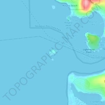
Name: Deception Island topographic map, elevation, terrain.

Location: Deception Island, Island County, Washington, United States (48.40654 -122.67250 48.40865 -122.66859)

Average elevation: 5 m

Minimum elevation: -4 m

Maximum elevation: 121 m

Other topographic maps

Click on a map to view its topography, its elevation and its terrain.

Walla Walla

United States > Washington > Walla Walla County

Walla Walla County features a varied topography characterized by rolling hills, valleys, and river systems. The elevation in the area averages around 940 feet (approximately 287 meters) above sea level, with some areas rising to nearly 1,200 feet. The landscape is shaped by the Walla Walla River, which carves…

Average elevation: 297 m

Ozette Lake

United States > Washington

Average elevation: 44 m

Buckley

United States > Washington > Pierce County > Buckley > Buckley

Average elevation: 235 m

Inchelium

United States > Washington > Ferry County

Average elevation: 639 m

Acme

United States > Washington > Whatcom County

Average elevation: 420 m

Riverside State Park

United States > Washington > Spokane County > Spokane

Terrain in park is varied, with steep valleys along the rivers and more flat plateaus above. The Spokane River falls from approximately 1,680 feet when it enters the park in the south to approximately 1,540 feet at the Long Lake Reservoir on the northern edge of the park. Surrounding plateaus rise to 2,200…

Average elevation: 645 m

Okanogan County

United States > Washington

Average elevation: 1,208 m

Whatcom County

United States > Washington

Average elevation: 1,919 m

Cowlitz County

United States > Washington

Average elevation: 130 m

Centerville

United States > Washington

Average elevation: 488 m

Argonne Forest

United States > Washington

Average elevation: 110 m

Michigan Hill

United States > Washington

Average elevation: 114 m

Tulalip Shores

United States > Washington

Average elevation: 34 m

Snoqualmie Pass

United States > Washington > King County

Due to its elevation, Snoqualmie Pass experiences significantly lower temperatures than Seattle, and receives much more precipitation, much of it being snow. Snoqualmie Pass has a humid continental climate (Koppen: Dsb bordering Csb) with cold, very wet and snowy winters, and mild to warm, relatively dry…

Average elevation: 1,048 m

Cascade Mountain

United States > Washington

Average elevation: 1,240 m

Bamber Mountain

United States > Washington

Average elevation: 1,143 m

McClellan Butte

United States > Washington

Average elevation: 1,014 m

Methow River

United States > Washington

Average elevation: 1,408 m

Middle Mountain

United States > Washington

Average elevation: 1,287 m

Cougar Mountain

United States > Washington

Average elevation: 1,568 m

Liberty

United States > Washington

Average elevation: 239 m

Thurston

United States > Washington

Average elevation: 295 m

Lewis

United States > Washington

Average elevation: 563 m

Mason County

United States > Washington

Average elevation: 99 m

Terrace Heights

United States > Washington

Average elevation: 396 m

Pear Butte

United States > Washington

Average elevation: 1,618 m

Colchuck Lake

United States > Washington > Chelan County

Colchuck Lake has an area of approximately 87.8 acres (0.355 km2) and a maximum surface elevation of 5,570 feet above sea level, depending on the fluctuation of the depth of the lake. The lake has a tributary basin of 941 acres (3.81 km2) acres, and an average storage capacity estimated at 1,570 acre-feet.

Average elevation: 1,886 m

Lake Chelan

United States > Washington > Chelan County > Chelan

Lake Chelan (/ʃəˈlæn/ shə-LAN) is a narrow, 50.5 mi (81.3 km) long lake in Chelan County, north-central Washington state, U.S. It is an overdeepened lake and resembles a fjord, with an average width of 1.3 mi (2.1 km). Near its upper end, the lake surface lies more than 6,600 ft (2,000 m) below peaks less…

Average elevation: 1,358 m

Chambers Bay

United States > Washington > Steilacoom

Average elevation: 37 m

Allyn

United States > Washington > Mason County

Average elevation: 45 m

Eltopia

United States > Washington > Franklin County

Average elevation: 211 m

Bell Hill

United States > Washington > Clallam County > Bell Hill

Bell Hill is located in eastern Clallam County and is bordered to the north by the city of Sequim. The community is named for the hill that it sits on, which rises to an elevation of over 1,000 feet (300 m) above sea level, or more than 800 feet (240 m) above the center of Sequim. Bell Hill actually has two…

Average elevation: 139 m

Northwoods

United States > Washington > Skamania County

Average elevation: 447 m

Ryderwood

United States > Washington > Cowlitz County

Average elevation: 158 m

Wauconda

United States > Washington > Okanogan County

Average elevation: 1,183 m

Belfair

United States > Washington > Kitsap County > Bremerton

Average elevation: 103 m

Hansville

United States > Washington > Kitsap County

Average elevation: 14 m

Happy Valley

United States > Washington > Clallam County

Average elevation: 237 m

Hobart

United States > Washington > King County

Average elevation: 235 m

Grand Coulee

United States > Washington > Grant County

Average elevation: 502 m

Eufaula

United States > Washington > Cowlitz County

Average elevation: 126 m

Goose Prairie

United States > Washington > Yakima County

Average elevation: 1,156 m

Kamiak Butte

United States > Washington > Whitman County

Average elevation: 883 m

Bremer

United States > Washington > Lewis County

Average elevation: 430 m

Pilchuck

United States > Washington > Snohomish County

Average elevation: 199 m

Sunrise

United States > Washington > Pierce County

Average elevation: 1,755 m

Manson

United States > Washington > Chelan County

Average elevation: 362 m

Fords Prairie

United States > Washington > Lewis County

Average elevation: 67 m

Millwood

United States > Washington > Spokane County

The topography of the city is mostly flat as it lies on the floor of the Spokane Valley, though it does slope gently down towards the north. The northern edge of town is defined by the Spokane River, where the terrain promptly drops about 20 feet down to the river bank.

Average elevation: 600 m

Manchester

United States > Washington > Kitsap County

Average elevation: 42 m

Belfair

United States > Washington > Mason County

Average elevation: 63 m

Bryant

United States > Washington > Snohomish County

Average elevation: 63 m

Havillah

United States > Washington > Okanogan County

Average elevation: 1,117 m

Felida

United States > Washington > Clark County

Average elevation: 37 m

Gleed

United States > Washington > Yakima County

Average elevation: 424 m

Waller

United States > Washington > Pierce County > Tacoma

Average elevation: 59 m

Rome

United States > Washington > Whatcom County

Average elevation: 142 m

Oso

United States > Washington > Snohomish County

Average elevation: 118 m

Enetai

United States > Washington > Kitsap County

Average elevation: 38 m

Tracyton

United States > Washington > Kitsap County > Tracyton

Average elevation: 48 m

Nemah

United States > Washington > Pacific County

Average elevation: 19 m

Holly

United States > Washington > Kitsap County

Average elevation: 59 m

Chinook

United States > Washington > Pacific County

Average elevation: 3 m

Mead

United States > Washington > Spokane County

Average elevation: 585 m

Lochsloy

United States > Washington > Snohomish County

Average elevation: 112 m

Burbank

United States > Washington > Walla Walla County > Burbank

Average elevation: 115 m

Basin City

United States > Washington > Franklin County

Average elevation: 221 m

Anatone

United States > Washington > Asotin County

Average elevation: 1,097 m

Washtucna

United States > Washington > Adams County

It sits at the head of Washtucna Coulee, a thin but deep valley that runs west to Connell, Washington where it merges with Providence Coulee to form Esquatzel Coulee. Being located on the floor of the coulee, Washtucna is at relatively lower elevation than the terrain that surrounds it. The floor of the coulee…

Average elevation: 351 m

Benge

United States > Washington > Adams County

Average elevation: 479 m

Lind

United States > Washington > Adams County

Average elevation: 449 m

Hatton

United States > Washington > Adams County

Average elevation: 360 m

Ritzville

United States > Washington > Adams County

Average elevation: 565 m

Regal

United States > Washington > Kittitas County

Average elevation: 491 m

Fargher Lake

United States > Washington > Clark County

Average elevation: 224 m

Glencove

United States > Washington > Pierce County

Average elevation: 43 m

Sheridan

United States > Washington > Kitsap County > Bremerton

Average elevation: 50 m