Millwood topographic map
Interactive map
Click on the map to display elevation.
About this map
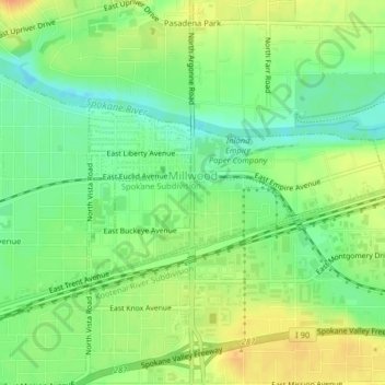
Name: Millwood topographic map, elevation, terrain.
Location: Millwood, Spokane County, Washington, United States (47.67891 -117.29348 47.69092 -117.26233)
Average elevation: 600 m
Minimum elevation: 582 m
Maximum elevation: 619 m
The topography of the city is mostly flat as it lies on the floor of the Spokane Valley, though it does slope gently down towards the north. The northern edge of town is defined by the Spokane River, where the terrain promptly drops about 20 feet down to the river bank.
Other topographic maps
Click on a map to view its topography, its elevation and its terrain.
Spokane
United States > Washington > Spokane County
Spokane, Spokane County, Washington, United States
Average elevation: 655 m
Newman Lake
United States > Washington > Spokane County
Newman Lake, Spokane County, Washington, 99025, United States
Average elevation: 661 m
Hog Lake
United States > Washington > Spokane County
Hog Lake, Spokane County, Washington, United States
Average elevation: 664 m
Silver Lake
United States > Washington > Spokane County
Silver Lake, Spokane County, Washington, 99022, United States
Average elevation: 741 m
Mead
United States > Washington > Spokane County
Mead, Spokane County, Washington, 99021, United States
Average elevation: 585 m
Country Homes
United States > Washington > Spokane County
Country Homes, Spokane County, Washington, 99251, United States
Average elevation: 599 m
Airway Heights
United States > Washington > Spokane County
Airway Heights, Spokane County, Washington, 99001, United States
Average elevation: 724 m
Cheney
United States > Washington > Spokane County
Cheney, Spokane County, Washington, United States
Average elevation: 728 m
Deer Park
United States > Washington > Spokane County
Deer Park, Spokane County, Washington, 99006, United States
Average elevation: 658 m
Mount Spokane
United States > Washington > Spokane County
Mount Spokane, Spokane County, Washington, United States
Average elevation: 1,475 m
Liberty Lake
United States > Washington > Spokane County
Liberty Lake, Spokane County, Washington, 99019, United States
Average elevation: 644 m
Spokane Valley
United States > Washington > Spokane County
Spokane Valley, Spokane County, Washington, United States
Average elevation: 673 m
Nine Mile Falls
United States > Washington > Spokane County
Nine Mile Falls, Spokane County, Washington, 99026, United States
Average elevation: 536 m
Riverside State Park
United States > Washington > Spokane County > Spokane
Riverside State Park, Spokane, Spokane County, Washington, United States
Average elevation: 645 m
Medical Lake
United States > Washington > Spokane County
Medical Lake, Spokane County, Washington, 99022, United States
Average elevation: 738 m
Medical Lake
United States > Washington > Spokane County > Medical Lake > Medical Lake
Medical Lake, Spokane County, Washington, 99022, United States
Average elevation: 747 m
Chattaroy
United States > Washington > Spokane County > Chattaroy
Chattaroy, Spokane County, Washington, 99005, United States
Average elevation: 559 m