
Make a donation
Morocco topographic map
Click on the map to display elevation.
Make a donation
Morocco
In the Rif, Middle and High Atlas Mountains, there exist several different types of climates: Mediterranean along the coastal lowlands, giving way to a humid temperate climate at higher elevations with sufficient moisture to allow for the growth of different species of oaks, moss carpets, junipers, and Atlantic fir which is a royal conifer tree endemic to Morocco. In the valleys, fertile soils and high precipitation allow for the growth of thick and lush forests. Cloud forests can be found in the west of the Rif Mountains and Middle Atlas Mountains. At higher elevations, the climate becomes alpine in character, and can sustain ski resorts.
Make a donation
About this map
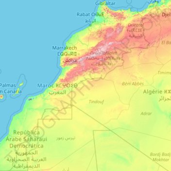
Name: Morocco topographic map, elevation, terrain.
Location: Morocco (21.33346 -17.24484 36.00214 -0.99843)
Average elevation: 371 m
Minimum elevation: -59 m
Maximum elevation: 3,641 m
Make a donation
Other topographic maps
Click on a map to view its topography, its elevation and its terrain.
KuGompo City
South Africa > Eastern Cape > Buffalo City Metropolitan Municipality
Average elevation: 72 m
Gaborone
Botswana > South-East District
Gaborone is situated at 24°39′29″S 25°54′44″E / 24.65806°S 25.91222°E / -24.65806; 25.91222 between Kgale and Oodi Hills, on the Notwane River in the south-eastern corner of Botswana, and 15 kilometres (9.3 mi) from the South African border The city lies at an elevation of 1,010 metres…
Average elevation: 1,032 m
Nairobi National Park
Kenya > Nairobi County > Kajiado North > Nairobi
The park covers an area of 117.21 km2 (45.26 sq mi) and is small in comparison to most of Africa's national parks. The park's altitude ranges between 1,533 and 1,760 m (5,030 and 5,774 ft). It has a dry climate. The park is the only protected part of the Athi-Kapiti ecosystem, making up less than 10% of this…
Average elevation: 1,662 m
Make a donation
Nahoon River
South Africa > Eastern Cape > Buffalo City Metropolitan Municipality > KuGompo City
Average elevation: 65 m
Make a donation
KwaMhlanga
South Africa > Mpumalanga > Nkangala > Thembisile Hani Local Municipality
Average elevation: 1,338 m
Make a donation
Jabal Hafeet
United Arab Emirates > Abu Dhabi Emirate > Al Ain > Jabal Hafeet
Average elevation: 610 m
Make a donation
Loutraki
Greece > Peloponnese, Western Greece and the Ionian > Corinthia Regional Unit > Municipal Unit of Loutraki - Perachora
Average elevation: 225 m
Make a donation
Maunatlala
As time passed by Kgosi Mapena’s eldest son who was named Maunatlala died, the village’ name was changed from Kopung to Maunatlala. Climatic Conditions The climate of Maunatlala area is semi-arid with dry winters and fairly wet summer months, with drought endemic. The average precipitation for the area is…
Average elevation: 878 m
Grand Canyon
United States > Arizona > Coconino County
Uplift associated with mountain formation later moved these sediments thousands of feet upward and created the Colorado Plateau. The higher elevation has also resulted in greater precipitation in the Colorado River drainage area, but not enough to change the Grand Canyon area from being semi-arid. The uplift…
Average elevation: 1,023 m
Make a donation
Make a donation
Bloemspruit
South Africa > Free State > Mangaung Metropolitan Municipality > Bloemfontein
Average elevation: 1,376 m
Reykjahlíð
Reykjahlíð (Icelandic pronunciation: [ˈreiːcaˌl̥iːθ]) is a village situated on the shores of Lake Mývatn in the north of Iceland. It is the seat of the municipality of Þingeyjarsveit. It has 227 inhabitants as of 2021. With an elevation of 292 meters above sea level it ranks as the highest situated…
Average elevation: 305 m
Make a donation
Make a donation
Make a donation
Manang
Nepal > Gandaki Province > Manang
Manang (Nepali: मनाङ) is a town in the Manang District of Nepal. It is located at 28°40'0N 84°1'0E with an elevation of 3,519 metres (11,545 ft). According to the preliminary results of the 2011 Nepal census, the district has a population of 6,527 people living in 1,495 individual households. Its…
Average elevation: 3,855 m
Make a donation
Moody Lake
United States > Minnesota > Chisago County > Chisago Lake Township
Average elevation: 283 m
Make a donation
Thiruvananthapuram
India > Kerala > Thiruvananthapuram
Thiruvananthapuram is built on seven hills by the seashore and is at 8°30′N 76°54′E / 8.5°N 76.9°E / 8.5; 76.9 on the west coast, near the southern tip of mainland India. The city is on the west coast of India and is bounded by the Laccadive Sea to its west and the Western Ghats to its east.…
Average elevation: 33 m
Make a donation
Make a donation
Make a donation
Carolina
South Africa > Mpumalanga > Gert Sibande > Albert Luthuli Local Municipality
Average elevation: 1,675 m
Make a donation
Make a donation
Make a donation
Make a donation
Sierra Nevada de Santa Marta
Colombia > Magdalena > Aracataca
The Sierra Nevada de Santa Marta (English: Snow-Covered Mountain Range of Saint Martha) is an isolated mountain range in northern Colombia, separate from the Andes range that runs through the north of the country. Reaching an elevation of 5,700 m (18,700 ft) just 42 km (26 mi) from the Caribbean coast, the…
Average elevation: 5,013 m
Ernakulam
India > Kerala > Kanayannur
The Ernakulam District is situated in Central Kerala in India. Ernakulam is located at the geographic coordinates of 9°58′53.8″N 76°17′59.6″E / 9.981611°N 76.299889°E / 9.981611; 76.299889 and at an elevation of 22.36 m (73.4 ft) above the mean sea level.
Average elevation: 6 m
Make a donation
Elephant Pound Rajaji National park Uttrakhand
India > Uttarakhand > Yamkeshwar
Average elevation: 455 m
Kayseri
Kayseri sits at the foot of Mount Erciyes (Turkish: Erciyes Dağı), a dormant volcano that reaches an altitude of 3,917 metres (12,851 feet), more than 1,500 metres above the city's mean altitude. It contains a number of historic monuments, particularly from the Seljuk period. Tourists often pass through…
Average elevation: 1,345 m
Make a donation
Make a donation
Heard Island
Heard Island, by far the largest of the group, is a 368-square-kilometre (142 sq mi) mountainous island covered by 41 glaciers; 80% of the island is covered with ice. The Big Ben massif dominates the island: It has a maximum elevation of 2,745 metres (9,006 ft) at Mawson Peak, the historically active volcanic…
Average elevation: 120 m
Make a donation
Make a donation
Baie de Nekkour
Morocco > Tangier-Tetouan-Al Hoceima > Ajdir أجدير > Sidi Mohamedi
Average elevation: 21 m
Make a donation