
Make a donation
Chula Vista topographic map
Click on the map to display elevation.
Make a donation
About this map
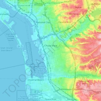
Name: Chula Vista topographic map, elevation, terrain.
Location: Chula Vista, California, United States (32.57797 -117.12401 32.68562 -116.92773)
Average elevation: 42 m
Minimum elevation: -3 m
Maximum elevation: 174 m
Make a donation
Other topographic maps
Click on a map to view its topography, its elevation and its terrain.
Mount Shasta
United States > California > Siskiyou County
Mount Shasta (/ˈʃæstə/ SHASS-tə; Shasta: Waka-nunee-Tuki-wuki; Karuk: Úytaahkoo) is a potentially active stratovolcano at the southern end of the Cascade Range in Siskiyou County, California. At an elevation of 14,179 ft (4,322 m), it is the second-highest peak in the Cascades and the fifth-highest in…
Average elevation: 3,717 m
Make a donation
Elk Creek
United States > California > Glenn County > Elk Creek
Elk Creek is a census-designated place in Glenn County, California. It is located 19 miles (31 km) northwest of Willows, at an elevation of 745 feet (227 m).
Average elevation: 258 m