
Thank you for supporting this site ❤️
Make a donation
Make a donation
Pinheiro topographic map
Click on the map to display elevation.
Thank you for supporting this site ❤️
Make a donation
Make a donation
About this map
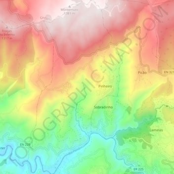
Name: Pinheiro topographic map, elevation, terrain.
Location: Pinheiro, Castro Daire, Viseu, Portugal (40.90463 -8.01086 40.97644 -7.95866)
Average elevation: 817 m
Minimum elevation: 262 m
Maximum elevation: 1,366 m
Thank you for supporting this site ❤️
Make a donation
Make a donation
Other topographic maps
Click on a map to view its topography, its elevation and its terrain.