
Make a donation
Chihuahua topographic map
Click on the map to display elevation.
Make a donation
Chihuahua
The main mountain range in the state is the Sierra Madre Occidental reaching a maximum altitude of 10,826 ft (3,300 m) known as Cerro Mohinora. Mountains account for one third of the state's surface area which include large coniferous forests. The climate in the mountainous regions varies. Chihuahua has more forests than any other state in Mexico making the area a bountiful source of wood; the mountainous areas are rich in minerals important to Mexico's mining industry. Precipitation and temperature in the mountainous areas depends on the elevation. Between the months of November and March snow storms are possible in the lower elevations and are frequent in the higher elevations. There are several watersheds located in the Sierra Madre Occidental all of the water that flows through the state; most of the rivers finally empty into the Río Grande. Temperatures in some canyons in the state reach over 100 °F (38 °C) in the summer while the same areas rarely drop below 32 °F (0 °C) in the winter. Microclimates found in the heart of the Sierra Madre Occidental in the state could be considered tropical, and wild tropical plants have been found in some canyons. La Barranca del Cobre, or Copper Canyon, a spectacular canyon system larger and deeper than the Grand Canyon; the canyon also contains Mexico's two tallest waterfalls: Basaseachic Falls and Piedra Volada. There are two national parks found in the mountainous area of the state: Cumbres de Majalca National Park and Basaseachic Falls National Park.
Make a donation
About this map
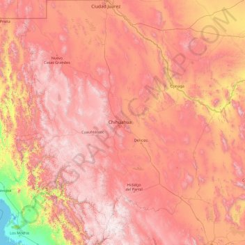
Name: Chihuahua topographic map, elevation, terrain.
Location: Chihuahua, Mexico (25.55866 -109.07498 31.78392 -103.30669)
Average elevation: 1,397 m
Minimum elevation: -1 m
Maximum elevation: 3,119 m
Make a donation
Other topographic maps
Click on a map to view its topography, its elevation and its terrain.
San Miguel el Alto
Mexico > Jalisco > San Miguel el Alto > San Miguel el Alto
Average elevation: 1,887 m
Atotonilco El Alto
Mexico > Jalisco > Atotonilco el Alto > Atotonilco El Alto
Average elevation: 1,712 m
Make a donation
Make a donation
Jilotlan de los Dolores
Mexico > Jalisco > Jilotlán de los Dolores > Jilotlan de los Dolores
Average elevation: 862 m
Make a donation
Tamazula de Gordiano
Mexico > Jalisco > Tamazula de Gordiano > Tamazula de Gordiano
Average elevation: 1,222 m
Make a donation
San Sebastián del Sur
Mexico > Jalisco > Gómez Farías > San Sebastián del Sur
Average elevation: 1,623 m
Make a donation
Paseos del Valle
Mexico > Jalisco > Tlajomulco de Zuñiga > Santa Cruz del Valle > Paseos del Valle
Average elevation: 1,532 m
Make a donation
Make a donation
San Diego de Alejandría
Mexico > Jalisco > San Diego de Alejandría > San Diego de Alejandría
Average elevation: 1,882 m
Unión de San Antonio
Mexico > Jalisco > Unión de San Antonio > Unión de San Antonio
Average elevation: 1,900 m
Make a donation
Delegación de la Pila
Mexico > San Luis Potosi > Municipio de San Luis Potosí > Delegación de la Pila
Average elevation: 1,868 m
Make a donation