
Make a donation
Pass Christian topographic map
Click on the map to display elevation.
Make a donation
Pass Christian
On August 29, 2005, Pass Christian was almost completely destroyed by Hurricane Katrina. Of the approximately 8,000 homes in Pass Christian, all but 500 were damaged or destroyed. In spite of the fact that the beachfront Scenic Drive follows the crest of a small bluff, affording it some elevation, most of the historic mansions along the road were severely damaged, and many were completely destroyed, including the superbly restored Greek Revival mansion "Union Quarters" described in the National Register of Historic Places as having been built in 1855. A cast-iron fence fronted the property, enclosing a Magnolia Historical Marker which was dedicated in 1960. It read, "Union officers were temporarily quartered here during the invasion of Pass Christian."
Make a donation
About this map
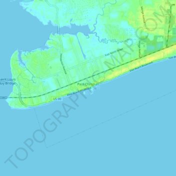
Name: Pass Christian topographic map, elevation, terrain.
Location: Pass Christian, Harrison County, Mississippi, United States (30.28425 -89.28731 30.34334 -89.18690)
Average elevation: 2 m
Minimum elevation: -3 m
Maximum elevation: 14 m
Make a donation
Other topographic maps
Click on a map to view its topography, its elevation and its terrain.
Make a donation
Make a donation
Make a donation
Jack and Florence Goldin Sportsplex
United States > Mississippi > Harrison County > Gulfport
Average elevation: 13 m
Make a donation
Make a donation