
Thank you for supporting this site ❤️
Make a donation
Make a donation
Gulfport topographic map
Click on the map to display elevation.
Thank you for supporting this site ❤️
Make a donation
Make a donation
About this map
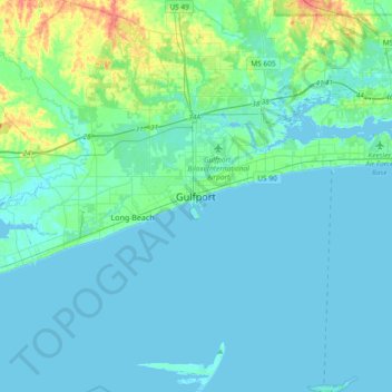
Name: Gulfport topographic map, elevation, terrain.
Location: Gulfport, Harrison County, Mississippi, 39502, United States (30.20742 -89.25282 30.52742 -88.93282)
Average elevation: 7 m
Minimum elevation: -5 m
Maximum elevation: 52 m
Thank you for supporting this site ❤️
Make a donation
Make a donation
Other topographic maps
Click on a map to view its topography, its elevation and its terrain.
Jack and Florence Goldin Sportsplex
United States > Mississippi > Harrison County > Gulfport
Average elevation: 13 m