
Thank you for supporting this site ❤️
Make a donation
Make a donation
Handsboro topographic map
Click on the map to display elevation.
Thank you for supporting this site ❤️
Make a donation
Make a donation
About this map
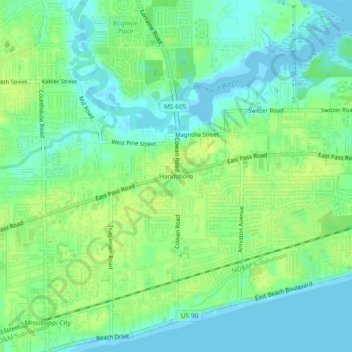
Name: Handsboro topographic map, elevation, terrain.
Average elevation: 8 m
Minimum elevation: -7 m
Maximum elevation: 16 m
Thank you for supporting this site ❤️
Make a donation
Make a donation
Other topographic maps
Click on a map to view its topography, its elevation and its terrain.
Jack and Florence Goldin Sportsplex
United States > Mississippi > Harrison County > Gulfport
Average elevation: 13 m