
龙田镇 topographic map
Interactive map
Click on the map to display elevation.
About this map
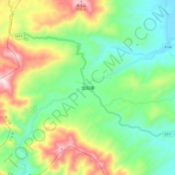
Name: 龙田镇 topographic map, elevation, terrain.
Location: 龙田镇, 宁乡市, 长沙市, 湖南省, 中国 (27.98242 111.90305 28.06242 111.98305)
Average elevation: 478 m
Minimum elevation: 192 m
Maximum elevation: 1,006 m
龙田镇是山区乡镇,平均海拔571米,森林覆盖率82.6%。龙田镇的山野间有樱花。
Other topographic maps
Click on a map to view its topography, its elevation and its terrain.