
誓节镇 topographic map
Interactive map
Click on the map to display elevation.
About this map
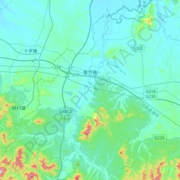
Name: 誓节镇 topographic map, elevation, terrain.
Location: 誓节镇, 广德市, 宣城市, 安徽省, 中国 (30.80765 119.06795 31.02517 119.36750)
Average elevation: 76 m
Minimum elevation: 11 m
Maximum elevation: 534 m
Other topographic maps
Click on a map to view its topography, its elevation and its terrain.