
甘子河乡 topographic map
Interactive map
Click on the map to display elevation.
About this map
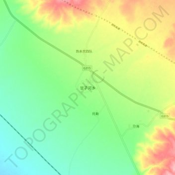
Name: 甘子河乡 topographic map, elevation, terrain.
Location: 甘子河乡, 海晏县, 海北藏族自治州, 青海省, 中国 (37.10845 100.49971 37.18845 100.57971)
Average elevation: 3,271 m
Minimum elevation: 3,218 m
Maximum elevation: 3,357 m
Other topographic maps
Click on a map to view its topography, its elevation and its terrain.