
Thank you for supporting this site ❤️
Make a donation
Make a donation
Santa Maria topographic map
Click on the map to display elevation.
Thank you for supporting this site ❤️
Make a donation
Make a donation
About this map
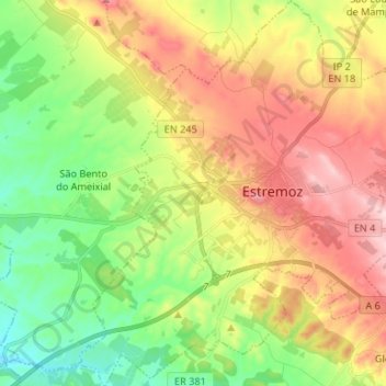
Name: Santa Maria topographic map, elevation, terrain.
Location: Santa Maria, Estremoz, Évora, Portugal (38.79105 -7.65357 38.89425 -7.52748)
Average elevation: 336 m
Minimum elevation: 223 m
Maximum elevation: 480 m
Thank you for supporting this site ❤️
Make a donation
Make a donation
Other topographic maps
Click on a map to view its topography, its elevation and its terrain.