
西峡县 topographic map
Interactive map
Click on the map to display elevation.
About this map
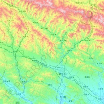
Name: 西峡县 topographic map, elevation, terrain.
Location: 西峡县, 南阳市, 河南省, 中国 (33.08797 110.99113 33.80194 111.83088)
Average elevation: 684 m
Minimum elevation: 165 m
Maximum elevation: 2,111 m
西峡县位于伏牛山南麓,东经111°01′ - 111°46′,北纬33°05′ - 33°48′。全县以中山、低山为主,北部伏牛山主峰老界岭是自西向东走向,侧脉由北向南延伸,地势从西北到东南倾斜。全县最高峰为老界岭主峰犄角尖海拔2212.5米,最低点海拔181米,位于丹水镇马边村。
Other topographic maps
Click on a map to view its topography, its elevation and its terrain.