
Make a donation
Cagayan de Oro topographic map
Click on the map to display elevation.
Make a donation
Cagayan de Oro
Cagayan de Oro, located along the north-central coast of Mindanao, Philippines, encompasses a diverse topography that significantly influences its terrain. The city spans approximately 488.86 square kilometers (188.75 square miles), featuring a 25-kilometer (16 miles) coastline along Macajalar Bay. The landscape transitions from a narrow coastal plain to rolling hills and steeply inclined mountains as one moves inland. The Cagayan River, originating from the Kalatungan Mountain Range in Bukidnon, traverses the city before emptying into the bay, carving valleys and contributing to the area's varied elevation. This diverse terrain not only shapes the city's natural beauty but also impacts urban development and land use patterns.
Make a donation
About this map
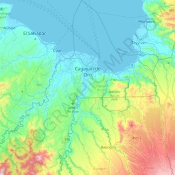
Name: Cagayan de Oro topographic map, elevation, terrain.
Location: Cagayan de Oro, Northern Mindanao, 9000, Philippines (8.25182 124.44721 8.62942 124.79667)
Average elevation: 224 m
Minimum elevation: -4 m
Maximum elevation: 1,000 m
Make a donation
Other topographic maps
Click on a map to view its topography, its elevation and its terrain.
Manila
Almost all of Manila sits on top of centuries of prehistoric alluvial deposits built by the waters of the Pasig River and on some land reclaimed from Manila Bay. Manila's land has been altered substantially by human intervention, with considerable land reclamation along the waterfronts since the American…
Average elevation: 13 m
Make a donation
Make a donation
San Mateo
The main source of the municipality's water supply are deep wells, pump wells (operated by Manila Water), open wells, springs and other ground water resources. Some of the elevated parts of the municipality are under watershed protected areas since the topography is characterized by rolling to mountainous…
Average elevation: 68 m
Make a donation
Make a donation
Make a donation
Lake Sebu
The placid lake of Lake Sebu can be found in Allah Valley near the municipality of Surallah, South Cotabato. Surrounded by rolling hills and mountains covered with thick rain forest, the lake has an area of 354 hectares (870 acres), with an elevation of approximately 1,000 metres (3,300 ft).
Average elevation: 750 m
Antipolo
Its higher elevation than that of Metro Manila affords it a scenic view of the metropolis, especially at night. Its locally grown mangoes and cashews are popular among tourists, as well as suman – a local delicacy made out of glutinous rice. The Hinulugang Taktak National Park, which was once a popular…
Average elevation: 125 m
Make a donation
Make a donation
Make a donation
Make a donation
Make a donation
Make a donation
Make a donation