
Make a donation
Wheaton topographic map
Click on the map to display elevation.
Make a donation
About this map
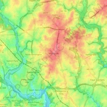
Name: Wheaton topographic map, elevation, terrain.
Location: Wheaton, Montgomery County, Maryland, 20902, United States (38.99983 -77.09526 39.07983 -77.01526)
Average elevation: 101 m
Minimum elevation: 56 m
Maximum elevation: 148 m
Make a donation
Other topographic maps
Click on a map to view its topography, its elevation and its terrain.
Make a donation
Make a donation
Darnestown
United States > Maryland > Montgomery County
In the 2000 census, the Census Bureau created a new Census-designated place (CDP) called Darnestown. A Darnestown CDP was also used in the 2010 census. The Darnestown CDP has 16.39 square miles (42.4 km2) of land, which is smaller than the old Darnestown MCD. The CDP uses the Muddy Branch, Turkey Foot Road,…
Average elevation: 97 m
Make a donation
Travilah
United States > Maryland > Montgomery County > Travilah
The United States Geological Survey lists six features in Montgomery County with Travilah in all or part of their name. The Travilah Census Designated Place has an ID of 2390400 and an elevation of 233 feet. It has a latitude of 390325N and a longitude of 0771445W—a location of 39°3′25″N…
Average elevation: 96 m
Make a donation
North Kensington
United States > Maryland > Montgomery County > North Kensington
Average elevation: 103 m
Montgomery Village
United States > Maryland > Montgomery County > Montgomery Village
Average elevation: 132 m
Make a donation