
Make a donation
Clarksburg topographic map
Click on the map to display elevation.
Make a donation
About this map
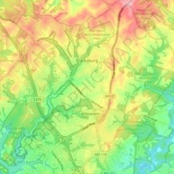
Name: Clarksburg topographic map, elevation, terrain.
Location: Clarksburg, Montgomery County, Maryland, United States (39.18392 -77.30556 39.25485 -77.21797)
Average elevation: 166 m
Minimum elevation: 97 m
Maximum elevation: 247 m
Make a donation
Other topographic maps
Click on a map to view its topography, its elevation and its terrain.
Make a donation
Quail Ridge
United States > Maryland > Montgomery County > Montgomery Village
Average elevation: 133 m
Make a donation
Great Falls
United States > Maryland > Montgomery County > Potomac
The rocks of the falls date to the late Precambrian and are about 750 million years old. The rocks are a resistant metamorphized schist, gneisses, metagraywackes, and metaconglomerates. The Falls formed the last time sea level dropped, during the Last Glacial Period about 35,000 years ago, causing the Potomac…
Average elevation: 73 m
Make a donation
Seneca
United States > Maryland > Montgomery County > Darnestown
Seneca is located close to the intersection of River Road (Maryland Route 190), Seneca Road (Maryland route 112), and Rileys Lock Road, east of Great Seneca Creek and north of the Potomac River. The C&O Canal runs along the river, and Riley's Lock is the closest canal lock. The southern portion of Seneca Creek…
Average elevation: 82 m
Make a donation
Make a donation
Make a donation
Rockcrest
United States > Maryland > Montgomery County > Rockville > Rockcrest
Average elevation: 114 m
Make a donation
Brookeville Heights
United States > Maryland > Montgomery County > Brookeville Heights
Average elevation: 139 m
Garrett Park Estates
United States > Maryland > Montgomery County > Garrett Park Estates
Average elevation: 97 m
Make a donation