Geolocate

Grand Canyon National Park topographic map

Click on the map to display elevation.

Grand Canyon National Park

The topography of Grand Canyon National Park is defined by dramatic elevations and striking geological features. The park, located in Mohave County, Arizona, encompasses over 278 miles of the Colorado River and its surrounding plateaus. The canyon itself reaches depths of more than a mile (6,000 feet) from rim to river, with varying widths from 175 yards to 18 miles across. This impressive landscape showcases a complex array of geological layers, from ancient Vishnu Schist at the base, to the younger Kaibab Limestone capping the canyon. These formations reveal a deep record of Earth's geological history, with the canyon carved by millions of years of erosion from the Colorado River. The surrounding terrain includes rugged ridges, buttes, and mesas, while the elevations shift dramatically, from the riverbed at about 2,200 feet to the highest point at nearly 8,200 feet on the North Rim. Such variations in elevation foster a diversity of ecosystems, ranging from desert scrub at the lowest levels to forests of pinyon pine and ponderosa pine at higher altitudes.

About this map

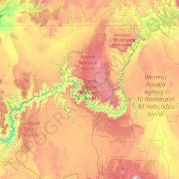
Name: Grand Canyon National Park topographic map, elevation, terrain.

Location: Grand Canyon National Park, Arizona, 86023, United States (35.75008 -113.97990 36.86569 -111.58704)

Average elevation: 1,685 m

Minimum elevation: 513 m

Maximum elevation: 3,757 m

Other topographic maps

Click on a map to view its topography, its elevation and its terrain.

Grand Canyon

United States > Arizona > Coconino County

Uplift associated with mountain formation later moved these sediments thousands of feet upward and created the Colorado Plateau. The higher elevation has also resulted in greater precipitation in the Colorado River drainage area, but not enough to change the Grand Canyon area from being semi-arid. The uplift…

Average elevation: 1,023 m

Scottsdale

United States > Arizona > Maricopa County > Scottsdale

The city is in the Salt River Valley, or the "Valley of the Sun," in the northern reaches of the Sonoran Desert. Scottsdale, 31 mi (50 km) long and 11.4 mi (18.3 km) wide at its widest point, shares boundaries with many other municipalities and entities. On the west, Scottsdale is bordered by Phoenix, Paradise…

Average elevation: 414 m

Glen Canyon

United States > Arizona > Coconino County

Average elevation: 1,248 m

Rio Rico

United States > Arizona > Santa Cruz County

Average elevation: 1,067 m

Hoover Dam

United States > Arizona > Mohave County

The amount of electricity generated by Hoover Dam has been decreasing along with the falling water level in Lake Mead due to the prolonged drought since year 2000 and high demand for the Colorado River's water. By 2014 its generating capacity was downrated by 23% to 1592 MW and was providing power only during…

Average elevation: 429 m

Yuma

United States > Arizona > Yuma County

Average elevation: 69 m

Tubac

United States > Arizona > Santa Cruz County

Average elevation: 1,010 m

Vail

United States > Arizona > Pima County > Vail

Average elevation: 1,035 m

Grand Canyon

United States > Arizona > Coconino County

Uplift associated with mountain formation later moved these sediments thousands of feet upward and created the Colorado Plateau. The higher elevation has also resulted in greater precipitation in the Colorado River drainage area, but not enough to change the Grand Canyon area from being semi-arid. The uplift…

Average elevation: 1,023 m

Peach Spring

United States > Arizona > Navajo County

Average elevation: 2,045 m

Peach Spring

United States > Arizona > Navajo County

Average elevation: 2,090 m

Red Hill

United States > Arizona > Apache County

Average elevation: 1,830 m

Bagdad

United States > Arizona > Yavapai County

Average elevation: 1,181 m

House Mountain

United States > Arizona > Yavapai County

Average elevation: 1,417 m

White Pocket

United States > Arizona > Coconino County

Average elevation: 1,737 m

Walker

United States > Arizona > Yavapai County

Average elevation: 2,039 m

Potato Patch

United States > Arizona > Yavapai County

Average elevation: 2,167 m

Iron Springs

United States > Arizona > Yavapai County

Average elevation: 1,828 m

Centerville

United States > Arizona > Yavapai County > Clarkdale

Average elevation: 1,103 m

Fortuna Foothills

United States > Arizona > Yuma County

Average elevation: 113 m

McNeal

United States > Arizona > Cochise County

Average elevation: 1,269 m

Oak Creek

United States > Arizona > Yavapai County > Sedona

Average elevation: 1,295 m

Bird Lake

United States > Arizona > Maricopa County > Phoenix

Average elevation: 345 m

Lynx Lake

United States > Arizona > Yavapai County

Lynx Lake, Arizona, is a 55-acre (220,000 m2) reservoir located within Prescott National Forest, approximately 5 miles (8.0 km) east of Prescott, Arizona, in the Bradshaw Mountains. The lake is located at 5,530 feet (1,690 m) elevation and is stocked for fishing. It is one of the most popular recreation areas…

Average elevation: 1,726 m

Mint

United States > Arizona > Yavapai County

Average elevation: 1,532 m

Buckshot

United States > Arizona > Yuma County

Average elevation: 52 m

Poland Junction

United States > Arizona > Yavapai County

Average elevation: 1,499 m

Antelope Canyon

United States > Arizona > Coconino County

Average elevation: 1,205 m

Mather Point

United States > Arizona > Coconino County

Average elevation: 1,800 m

Antelope Island

United States > Arizona > Coconino County > Wahweap

Average elevation: 1,137 m

Chinle

United States > Arizona > Apache County > Chinle

Average elevation: 1,715 m

Groom Creek

United States > Arizona > Yavapai County

Average elevation: 1,975 m

Concho

United States > Arizona > Apache County

Average elevation: 1,844 m

White Pocket

United States > Arizona > Coconino County

Average elevation: 1,737 m

Concho

United States > Arizona > Apache County

Average elevation: 1,844 m

Madera Canyon

United States > Arizona > Santa Cruz County

Average elevation: 1,882 m

Beaver Valley Estates

United States > Arizona > Gila County

Average elevation: 1,564 m

Toyei

United States > Arizona > Apache County

Average elevation: 1,993 m

Shonto

United States > Arizona > Navajo County

Average elevation: 1,963 m

Copper Hill

United States > Arizona > Gila County

Average elevation: 1,247 m

Green Valley

United States > Arizona > Pima County > Sahuarita

Average elevation: 962 m

Bull Canyon

United States > Arizona > Gila County

Average elevation: 1,190 m

Humphreys Peak

United States > Arizona > Coconino County

Humphreys Peak (Hopi: Aaloosaktukwi, Navajo: Dookʼoʼoosłííd "its summit never melts") is the highest mountain and the second most prominent peak after Mount Graham in the U.S. state of Arizona. With an elevation of 12,637 feet (3,852 m), it is located within the Kachina Peaks Wilderness in the Coconino…

Average elevation: 3,412 m

Indian Pine

United States > Arizona > Navajo County

Average elevation: 2,194 m

Twin Butte

United States > Arizona > Maricopa County > Tempe

Average elevation: 353 m

Salome

United States > Arizona > La Paz County

Average elevation: 573 m

Granite Mountain

United States > Arizona > Yavapai County

Average elevation: 1,915 m

Rosedale Heights

United States > Arizona > Navajo County > Holbrook

Average elevation: 1,571 m

Hackberry

United States > Arizona > Mohave County

Average elevation: 1,162 m

Verde Valley

United States > Arizona > Yavapai County > Cottonwood

Average elevation: 1,311 m

Pinetop

United States > Arizona > Navajo County > Pinetop-Lakeside

Average elevation: 2,141 m

Crystal Beach

United States > Arizona > Mohave County

Average elevation: 172 m

Sacred Mountain

United States > Arizona > Yavapai County

Average elevation: 1,223 m

Ramsey Peak

United States > Arizona > Cochise County > Sierra Vista

Average elevation: 2,317 m

Joe Tank

United States > Arizona > Navajo County

Average elevation: 1,994 m

Mitchell Park

United States > Arizona > Pima County > Tucson

Average elevation: 731 m

Oak Creek Canyon

United States > Arizona > Coconino County

Oak Creek Canyon is about 12 miles (19 km) long, ranging in width from 0.8 to 2.5 miles (1.3 to 4.0 km). The depth of the canyon ranges from 800 to 2,000 feet (240 to 610 m). However, due to the faulting that played a major role in its formation, the west rim of the canyon is 700 feet (210 m) higher than the…

Average elevation: 1,859 m

Many Farms

United States > Arizona > Apache County

Average elevation: 1,641 m

Three Points

United States > Arizona > Pima County

Average elevation: 869 m

Topock

United States > Arizona > Mohave County

Average elevation: 180 m

Arcosanti

United States > Arizona > Yavapai County

Arcosanti is a projected experimental town with a molten bronze bell casting business in Yavapai County, central Arizona, United States, 70 mi (110 km) north of Phoenix, at an elevation of 3,732 feet (1,138 m). Its arcology concept was proposed by the Italian-American architect Paolo Soleri (1919–2013). He…

Average elevation: 1,130 m

Oro Blanco

United States > Arizona > Santa Cruz County

Average elevation: 1,255 m

Grand Canyon

United States > Arizona > Coconino County

Uplift associated with mountain formation later moved these sediments thousands of feet upward and created the Colorado Plateau. The higher elevation has also resulted in greater precipitation in the Colorado River drainage area, but not enough to change the Grand Canyon area from being semi-arid. The uplift…

Average elevation: 1,023 m

Havasupai Gardens

United States > Arizona > Coconino County

Average elevation: 1,333 m

Crystal Beach

United States > Arizona > Mohave County

Average elevation: 172 m

Woods Canyon Lake

United States > Arizona > Coconino County

Average elevation: 2,321 m

Monument Valley

United States > Arizona > Navajo County

The area is part of the Colorado Plateau. The elevation of the valley floor ranges from 5,000 to 6,000 feet (1,500 to 1,800 m) above sea level. The floor is largely siltstone of the Cutler Group, or sand derived from it, deposited by the meandering rivers that carved the valley. The valley's vivid red color…

Average elevation: 1,675 m

Oracle Junction

United States > Arizona > Pinal County

Average elevation: 1,030 m

Sun Valley

United States > Arizona > Navajo County

Average elevation: 1,615 m

Ponderosa Park

United States > Arizona > Yavapai County

Average elevation: 1,783 m

Phoenix

United States > Arizona > Maricopa County > Phoenix

Phoenix is in the south-central portion of Arizona; about halfway between Tucson to the southeast and Flagstaff to the north, in the southwestern United States. By car, the city is approximately 150 miles (240 kilometers) north of the US–Mexico border at Sonoyta and 180 mi (290 km) north of the border at…

Average elevation: 368 m

Arivaca Junction

United States > Arizona > Pima County

Average elevation: 944 m

Kofa

United States > Arizona > Yuma County

Average elevation: 118 m

Oak Creek Canyon

United States > Arizona > Coconino County

Oak Creek Canyon is about 12 miles (19 km) long, ranging in width from 0.8 to 2.5 miles (1.3 to 4.0 km). The depth of the canyon ranges from 800 to 2,000 feet (240 to 610 m). However, due to the faulting that played a major role in its formation, the west rim of the canyon is 700 feet (210 m) higher than the…

Average elevation: 1,859 m

Tortilla

United States > Arizona > Pinal County

Average elevation: 1,109 m

Rio Rico

United States > Arizona > Santa Cruz County

Average elevation: 1,067 m

Cathedral Rock

United States > Arizona > Yavapai County

Cathedral Rock is a natural sandstone butte near Sedona, Arizona, and one of the most-photographed sights in Arizona, United States. The rock formation is located in the Coconino National Forest in Yavapai County, about 1 mi (1.6 km) west of Arizona Route 179, and about 2.5 mi (4.0 km) south of the "Y"…

Average elevation: 1,282 m

Grand Canyon

United States > Arizona > Coconino County

Uplift associated with mountain formation later moved these sediments thousands of feet upward and created the Colorado Plateau. The higher elevation has also resulted in greater precipitation in the Colorado River drainage area, but not enough to change the Grand Canyon area from being semi-arid. The uplift…

Average elevation: 1,023 m

Hassayampa

United States > Arizona > Maricopa County

Average elevation: 265 m

Vernon

United States > Arizona > Apache County

Average elevation: 2,119 m

Lakeside

United States > Arizona > Navajo County > Pinetop-Lakeside

Average elevation: 2,059 m

Four Peaks

United States > Arizona > La Paz County

Average elevation: 407 m

Pinetop

United States > Arizona > Navajo County > Pinetop-Lakeside

Average elevation: 2,141 m

Twin Butte

United States > Arizona > Maricopa County > Tempe

Average elevation: 353 m

San Simon

United States > Arizona > Cochise County

Average elevation: 1,101 m