
Make a donation
Crozier topographic map
Click on the map to display elevation.
Make a donation
About this map
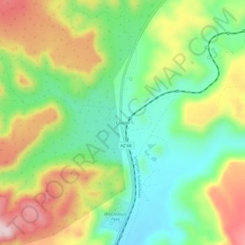
Name: Crozier topographic map, elevation, terrain.
Location: Crozier, Mohave County, Arizona, 86437, United States (35.40499 -113.66903 35.44499 -113.62903)
Average elevation: 1,302 m
Minimum elevation: 1,179 m
Maximum elevation: 1,477 m
Make a donation
Other topographic maps
Click on a map to view its topography, its elevation and its terrain.
Kingman
United States > Arizona > Mohave County > Kingman
Lt. Edward Fitzgerald Beale, a U.S. Navy officer in the service of the U.S. Army Corps of Topographical Engineers, was ordered by the U.S. War Department to build a federal wagon road across the 35th Parallel. His secondary orders were to test the feasibility of the use of camels as pack animals in the…
Average elevation: 1,131 m
Make a donation
Kingman
United States > Arizona > Mohave County
Lt. Edward Fitzgerald Beale, a U.S. Navy officer in the service of the Army Corps of Topographical Engineers, was ordered by the U.S. War Department to build a federal wagon road across the 35th parallel. His secondary orders were to test the feasibility of the use of camels as pack animals in the Southwestern…
Average elevation: 1,131 m
Make a donation
Fort Mojave Indian Tribe
United States > Arizona > Mohave County > Mohave Valley
Average elevation: 362 m
Make a donation