
Thank you for supporting this site ❤️
Make a donation
Make a donation
Monteiras topographic map
Click on the map to display elevation.
Thank you for supporting this site ❤️
Make a donation
Make a donation
About this map
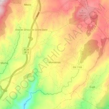
Name: Monteiras topographic map, elevation, terrain.
Location: Monteiras, Castro Daire, Viseu, Portugal (40.93396 -7.91374 40.97865 -7.83329)
Average elevation: 898 m
Minimum elevation: 622 m
Maximum elevation: 1,137 m
Thank you for supporting this site ❤️
Make a donation
Make a donation
Other topographic maps
Click on a map to view its topography, its elevation and its terrain.