
Make a donation
Norfolk topographic map
Click on the map to display elevation.
Make a donation
About this map
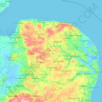
Name: Norfolk topographic map, elevation, terrain.
Location: Norfolk, England, United Kingdom (52.35534 0.15362 52.99164 1.74578)
Average elevation: 23 m
Minimum elevation: -4 m
Maximum elevation: 126 m
Make a donation
Other topographic maps
Click on a map to view its topography, its elevation and its terrain.
Leeds
Lying in the eastern foothills of the Pennines, there is a significant variation in elevation within the city's built-up area. The district ranges from 1,115 feet (340 m) in the far west on the slopes of Ilkley Moor to about 33 feet (10 m) where the rivers Aire and Wharfe cross the eastern boundary. Land rises…
Average elevation: 94 m
Cambridge
United Kingdom > England > Cambridge
The city, like most of the UK, has a maritime climate highly influenced by the Gulf Stream. Located in the driest region of Britain, Cambridge's rainfall averages around 570 mm (22.44 in) per year, around half the national average, with some years occasionally falling into the semi-arid (under 500 mm (19.69…
Average elevation: 18 m
Make a donation
Make a donation
Camelsdale
United Kingdom > England > Surrey > Waverley > Haslemere > Shottermill
Average elevation: 166 m
Make a donation
Portsmouth
United Kingdom > England > Hampshire > Portsmouth
By road, Portsmouth lies 73.5 miles (118.3 km) from Central London, 49.5 miles (79.7 km) west of Brighton, and 22.3 miles (35.9 km) east of Southampton. Portsmouth is situated primarily on Portsea Island and is the United Kingdom's only island city, although parts of it have expanded onto the mainland. Gosport…
Average elevation: 28 m
St Albans
United Kingdom > England > Hertfordshire > St Albans
St Albans was an ancient borough created following the dissolution of the monastery in 1539. It consisted of the ancient parish of St Albans (also known as the Abbey parish) and parts of St Michael and St Peter. The municipal corporation was reformed by the Municipal Corporations Act 1835 and the boundary was…
Average elevation: 100 m
Make a donation
Make a donation
Make a donation
Make a donation
Caterham
United Kingdom > England > Surrey > Tandridge
In 1840 Caterham contained a total of 477 residents (figures taken from that census, compiled in an 1848 topographical encyclopedia) and in 1848 468 acres (189 ha) of its 2,386 acres (966 ha) were common land. Similar to today, 175 acres (71 ha) mostly steeper acres were woodland.
Average elevation: 157 m
Make a donation
Basingstoke
United Kingdom > England > Hampshire > Basingstoke and Deane
Situated in a valley through the Hampshire Downs at an average elevation of 88 metres (289 ft) Basingstoke is a major interchange between Reading, Newbury, Andover, Winchester, and Alton, and lies on the natural trade route between the southwest of England and London. The area had been something of an…
Average elevation: 109 m
Make a donation
Hull
United Kingdom > England > Kingston upon Hull
Kingston upon Hull is on the northern bank of the Humber Estuary. The city centre is west of the River Hull and close to the Humber. The city is built upon alluvial and glacial deposits which overlie chalk rocks but the underlying chalk has no influence on the topography. The land within the city is generally…
Average elevation: 21 m
Hengistbury Head
United Kingdom > England > Bournemouth, Christchurch and Poole > Bournemouth
In 1910 the first international aviation meeting ever held in Britain took place on a specially laid out aerodrome consisting of a mile of grassland between the "Double Dykes" and the nearby village of Tuckton. About twenty pioneer aviators from around the world participated in various competitions including…
Average elevation: 0 m
Make a donation
Make a donation
Make a donation
Helvellyn
United Kingdom > England > Westmorland and Furness > Patterdale
Red Tarn, a classic corrie tarn, is a high-elevation tarn with low nutrient levels and poor in the number of species it supports. Characteristic vegetation zones include a water-starwort (Callitriche) in shallower areas and the alga Nitella flexilis in deeper water and around the inlet. Other species include a…
Average elevation: 680 m
Make a donation
Make a donation
Stamford Bridge
United Kingdom > England > Cheshire West and Chester > Great Barrow
Average elevation: 24 m
Make a donation
West Shield Row Villas
United Kingdom > England > County Durham > Stanley > Tanfield Lea
Average elevation: 180 m
Make a donation
Great Chishill
United Kingdom > England > Cambridgeshire > South Cambridgeshire
Average elevation: 112 m
Make a donation
Make a donation
Make a donation
Make a donation
City of London
United Kingdom > England > City of London > City of London
The elevation of the City ranges from sea level at the Thames to 21.6 metres (71 ft) at the junction of High Holborn and Chancery Lane. Two small but notable hills are within the historic core, Ludgate Hill to the west and Cornhill to the east. Between them ran the Walbrook, one of the many "lost" rivers or…
Average elevation: 42 m
Make a donation
Make a donation
Make a donation
Warlingham
United Kingdom > England > Warlingham
Elevations vary from 110m AOD at Woldingham Road, at the southernmost point of the parish, with a gentle increase in height through the village along the main road heading to the southeast, to the highest elevation (199.6m) at Limpsfield Road.
Average elevation: 165 m
Make a donation
Make a donation