
Derby topographic map
Click on the map to display elevation.
About this map
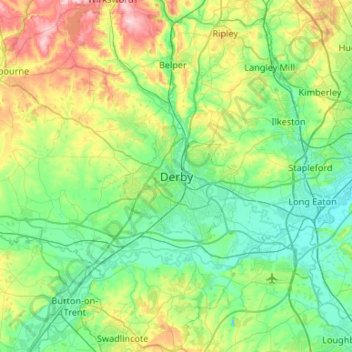
Name: Derby topographic map, elevation, terrain.
Average elevation: 97 m
Minimum elevation: 25 m
Maximum elevation: 317 m
Other topographic maps
Click on a map to view its topography, its elevation and its terrain.
Robin Wood
United Kingdom > England > Derbyshire > South Derbyshire > Stanton by Bridge CP
Average elevation: 92 m
Repton Shrubs
United Kingdom > England > Derbyshire > South Derbyshire > Repton CP
Average elevation: 110 m
New Mills
United Kingdom > England > Derbyshire > High Peak > Hague Bar
High Peak Borough Council have produced a Conservation Area Character Appraisal document, outlining the reasons that the Conservation Area has been designated as such. In justifying the reasons for designation, this document states of the town: "New Mills is a town of dramatic topography and origins that date…
Average elevation: 251 m
Crowden Great Brook
United Kingdom > England > Derbyshire > High Peak > Tintwistle > Crowden
Average elevation: 314 m
Newhall Wood
United Kingdom > England > Derbyshire > South Derbyshire > Newhall
Average elevation: 87 m
Bonsall CP
United Kingdom > England > Derbyshire > Derbyshire Dales > Matlock
Average elevation: 225 m
Haddon Hall
United Kingdom > England > Derbyshire > Derbyshire Dales > Alport
Average elevation: 158 m
Staunton Harold Reservoir
United Kingdom > England > Derbyshire > South Derbyshire > Melbourne CP
Average elevation: 93 m
Buxton
United Kingdom > England > Derbyshire > High Peak
Buxton has an oceanic climate with short, mild summers and long, cool winters. At about 1,000 feet (300 m) above sea level, As the highest market town in England, Buxton's elevation makes it cooler and wetter than surrounding towns, with a daytime temperature typically about 2 °C lower than Manchester.
Average elevation: 334 m
Riber Castle
United Kingdom > England > Derbyshire > Derbyshire Dales > Matlock > Starkholmes
Average elevation: 169 m
Dethick, Lea and Holloway CP
United Kingdom > England > Derbyshire > Amber Valley > Dethick
Average elevation: 204 m
Bakewell CP
United Kingdom > England > Derbyshire > Derbyshire Dales
The Manchester, Buxton, Matlock and Midlands Junction Railway opened Bakewell railway station in 1862, then became part of the Midland Railway and later of the LMS main line from London to Manchester. John Ruskin objected to what he saw as desecration of the Derbyshire countryside and to the fact that "a…
Average elevation: 194 m
Chapel-en-le-Frith
United Kingdom > England > Derbyshire > High Peak
In the rolling hills between Combs and Chapel is Bank Hall, extensively altered in 1872–74 for Henry Renshaw of Manchester on an ornate aerial plan with an elaborate stone balcony over the door, a bay window with fine botanical painted glass and canvas panels to the doors, formerly with painted panels by…
Average elevation: 324 m
Hartshorne
United Kingdom > England > Derbyshire > South Derbyshire > Swadlincote
Average elevation: 132 m
Crich CP
United Kingdom > England > Derbyshire > Amber Valley
The memorial tower ('Crich Stand') was completed in 1923 as a memorial to the 11,409 soldiers from the Sherwood Foresters Regiment who died in World War I, a dedication that was later extended to include World War II. It was built on an limestone outcrop above the village, at an altitude of 1,000 feet (300 m)…
Average elevation: 159 m
North Wingfield
United Kingdom > England > Derbyshire > North East Derbyshire
Average elevation: 126 m
Hathersage
United Kingdom > England > Derbyshire > Derbyshire Dales
The Fat Boys Stanage Struggle is a popular local fell race that starts in Hathersage—altitude 91 metres (299 ft)—and routes up to and along Stanage Edge to High Neb—458 metres (1,503 ft)—before returning to the village 367 metres (1,204 ft) below.
Average elevation: 311 m
Somersal Herbert CP
United Kingdom > England > Derbyshire > Somersal Herbert CP
Average elevation: 106 m
Elton
United Kingdom > England > Derbyshire > Derbyshire Dales
At 271 metres (889 ft) above sea level, Elton is less sheltered from the wind than settlements at lower elevation, and it therefore has a reputation for being cold. The highest point on Elton Moor, known as Blake Low, is 330 metres (1,080 ft) above sea level; at this location is Elton Common trig point…
Average elevation: 268 m
Ashbourne CP
United Kingdom > England > Derbyshire > Derbyshire Dales
Ashbourne lies at 53°01′N 01°44′W / 53.017°N 1.733°W / 53.017; -1.733. Ashbourne Green and Sturston are hamlets close by. Henmore Brook, a tributary of the River Dove, flows through the middle of the town. It has an elevation of 400 feet (122 m).
Average elevation: 147 m
Winster CP
United Kingdom > England > Derbyshire > Derbyshire Dales
Winster is a village in the English Derbyshire Dales about 5 miles (8 km) from Matlock and 6 miles (10 km) from Bakewell at an altitude of approximately 820 feet (250 m). It was formerly a centre for the lead mining industry. The village lies within the Peak District National Park and The Peak District…
Average elevation: 274 m
Tideswell CP
United Kingdom > England > Derbyshire > Derbyshire Dales
Tideswell is a village and civil parish in the Peak District of Derbyshire, England. It lies 6 miles (9.7 km) east of Buxton on the B6049, in a wide valley on a limestone plateau, at an altitude of 1,000 feet (300 m) above sea level, and is within the District of Derbyshire Dales. The population (including…
Average elevation: 321 m