
Uttarkashi topographic map
Interactive map
Click on the map to display elevation.
About this map
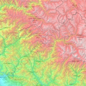
Name: Uttarkashi topographic map, elevation, terrain.
Location: Uttarkashi, Uttarakhand, India (30.36000 77.86000 31.64000 79.14000)
Average elevation: 3,290 m
Minimum elevation: 441 m
Maximum elevation: 6,928 m
Other topographic maps
Click on a map to view its topography, its elevation and its terrain.
Pindar Glacier
Pindar Glacier, Bageshwar, Uttarakhand, India
Average elevation: 4,447 m
Roorkee
India > Uttarakhand > Roorkee > Roorkee
Roorkee, Haridwar, Uttarakhand, 247667, India
Average elevation: 270 m
Milam Glacier
Milam Glacier, Pithoragarh, Uttarakhand, India
Average elevation: 5,223 m
Pithoragarh
India > Uttarakhand > Pithoragarh
Pithoragarh, Uttarakhand, 262500, India
Average elevation: 1,618 m
Bāgeshwar
India > Uttarakhand > Bāgeshwar
Bāgeshwar, Bageshwar, Uttarakhand, 263642, India
Average elevation: 1,154 m