
Ramnagar topographic map
Interactive map
Click on the map to display elevation.
About this map
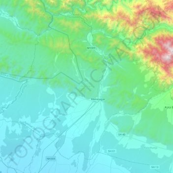
Name: Ramnagar topographic map, elevation, terrain.
Location: Ramnagar, Uttarakhand, India (29.25750 78.85049 29.58890 79.30198)
Average elevation: 555 m
Minimum elevation: 230 m
Maximum elevation: 2,549 m
Other topographic maps
Click on a map to view its topography, its elevation and its terrain.
Roorkee
India > Uttarakhand > Roorkee > Roorkee
Roorkee is located at 29°52′N 77°53′E / 29.87°N 77.88°E / 29.87; 77.88. It has an average elevation of 268 metres (879 feet).
Average elevation: 270 m
Dehradun
India > Uttarakhand > Dehradun
The city of Dehradun mainly lies in Doon Valley and is at a varying height from 410 m in Clement Town to above 700 m at Malsi which is 15 km from the city. However, the average elevation is 450 m above sea level. Malsi is the starting point of Lesser Himalayan Range that extends to Mussoorie and beyond.…
Average elevation: 904 m