
Tobol River topographic map
Interactive map
Click on the map to display elevation.
About this map
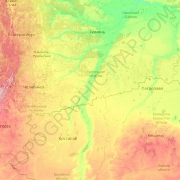
Name: Tobol River topographic map, elevation, terrain.
Location: Tobol River, Ural Federal District, 640008, Russia (51.40723 61.00818 58.15525 68.21730)
Average elevation: 200 m
Minimum elevation: 35 m
Maximum elevation: 1,068 m
Other topographic maps
Click on a map to view its topography, its elevation and its terrain.
Водолазово
Russia > Tyumen Oblast > Тушнолобовское сельское поселение > Водолазово
Average elevation: 74 m
Максимова
Russia > Tyumen Oblast > Тушнолобовское сельское поселение > Максимова
Average elevation: 75 m