
Blue Nile topographic map
Interactive map
Click on the map to display elevation.
Blue Nile
Although there are several feeder streams that flow into Lake Tana, the sacred source of the river is generally considered to be a small spring at Gish Abay, situated at an elevation of approximately 2,744 metres (9,003 ft). This stream, known as the Gilgel Abay (Lesser Abay River), flows north into Lake Tana. Other affluents of this lake include, in clockwise order from Gorgora, the Magech River, the Northern Gumara, the Reb River, the southern Gumara River, and the Kilte. Lake Tana's outflow then flows some 30 kilometres (19 mi) before plunging over the Blue Nile Falls. The river then loops across northwest Ethiopia through a series of deep valleys and canyons into Sudan, by which point it is only known as the Blue Nile.
About this map
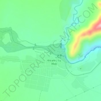
Name: Blue Nile topographic map, elevation, terrain.
Location: Blue Nile, South Gonder, Amhara Region, Ethiopia (11.48813 37.58253 11.49020 37.58613)
Average elevation: 1,647 m
Minimum elevation: 1,591 m
Maximum elevation: 1,768 m
Other topographic maps
Click on a map to view its topography, its elevation and its terrain.
Amhara Region
The Amhara region has the most world heritage sites of any region in Ethiopia and is endowed with natural and geographic wonders and ecosystems. The region contains Ethiopia's largest inland body of water Lake Tana, which is the source of the Blue Nile river. In 2015 Lake Tana was recognized as a UNESCO…
Average elevation: 1,618 m