British Columbia topographic map
Interactive map
Click on the map to display elevation.
About this map
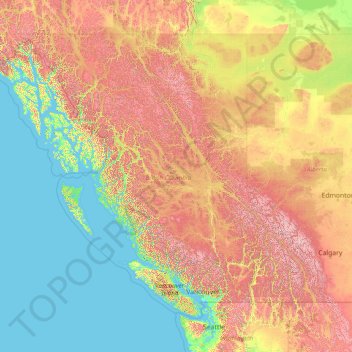
Name: British Columbia topographic map, elevation, terrain.
Location: British Columbia, Canada (48.22456 -139.06133 60.00207 -114.05414)
Average elevation: 708 m
Minimum elevation: -3 m
Maximum elevation: 3,625 m
The Southern Interior cities of Kamloops and Penticton have some of the warmest and longest summer climates in Canada (while higher elevations are cold and snowy), although their temperatures are often exceeded north of the Fraser Canyon, close to the confluence of the Fraser and Thompson rivers, where the terrain is rugged and covered with desert-type flora. Semi-desert grassland is found in large areas of the Interior Plateau, with land uses ranging from ranching at lower altitudes to forestry at higher ones.
Other topographic maps
Click on a map to view its topography, its elevation and its terrain.
Clarendon Parish
Clarendon Parish, Charlotte County, New Brunswick, Canada
Average elevation: 160 m
Ile-à-la-Crosse
Canada > Saskatchewan > Division No. 18
Ile-à-la-Crosse, Division No. 18, Saskatchewan, S0M 1C0, Canada
Average elevation: 423 m
Saint Quentin Parish
Saint Quentin Parish, Restigouche County, New Brunswick, E8A 1H5, Canada
Average elevation: 341 m
Inuvik
Canada > Northwest Territories
Inuvik, Northwest Territories, X0E 0T0, Canada
Average elevation: 29 m
Blainville
Canada > Quebec > Thérèse-De Blainville
Blainville, Thérèse-De Blainville, Laurentides, Quebec, Canada
Average elevation: 66 m
Parksville
Canada > British Columbia > Regional District of Nanaimo
Parksville, Regional District of Nanaimo, British Columbia, Canada
Average elevation: 38 m
Area D (Sproat Lake)
Canada > British Columbia > Alberni-Clayoquot Regional District
Area D (Sproat Lake), Alberni-Clayoquot Regional District, British Columbia, V9Y 8Y5, Canada
Average elevation: 615 m
Framboise
Canada > Nova Scotia > Municipality of the County of Richmond
Framboise, Municipality of the County of Richmond, Richmond County, Nova Scotia, Canada
Average elevation: 23 m
Vancouver Island
Vancouver Island, British Columbia, Canada
Average elevation: 411 m
Barrier Islands
Canada > Ontario > Kenora District > Unorganized Kenora District
Barrier Islands, Unorganized Kenora District, Kenora District, Northwestern Ontario, Ontario, Canada
Average elevation: 345 m
McMurrich
Canada > Ontario > Parry Sound District > McMurrich/Monteith Township
McMurrich, McMurrich/Monteith Township, Parry Sound District, Central Ontario, Ontario, Canada
Average elevation: 337 m
Axe Lake
Canada > Ontario > Kenora District > Unorganized Kenora District
Axe Lake, Unorganized Kenora District, Kenora District, Northwestern Ontario, Ontario, Canada
Average elevation: 369 m
Amherst
Canada > Quebec > Les Laurentides
Amherst, Les Laurentides, Laurentides, Quebec, J0T 2L0, Canada
Average elevation: 286 m
Division No. 18
Canada > Manitoba > Division No. 18
Division No. 18, Manitoba, Canada
Average elevation: 249 m
Scarborough Bluffs
Scarborough Bluffs, Toronto, Golden Horseshoe, Ontario, M1M 1C7, Canada
Average elevation: 120 m
Langford
Canada > British Columbia > Capital Regional District > Langford
Langford, Capital Regional District, British Columbia, Canada
Average elevation: 116 m
Mount Brewster
Canada > Alberta > Improvement District No. 9
Mount Brewster, Improvement District No. 9, Alberta, Canada
Average elevation: 2,305 m
Markham
Canada > Ontario > York Region > Markham
Markham, York Region, Golden Horseshoe, Ontario, Canada
Average elevation: 216 m
Central Saanich
Canada > British Columbia > Central Saanich
Central Saanich, Capital Regional District, British Columbia, Canada
Average elevation: 58 m
Kashechewan
Canada > Ontario > Kashechewan
Kashechewan, Kenora District, Northwestern Ontario, Ontario, P0L 1S0, Canada
Average elevation: 6 m
Georgetown
Canada > Ontario > Georgetown
Georgetown, Halton Hills, Halton Region, Golden Horseshoe, Ontario, L7G 4T3, Canada
Average elevation: 255 m
Negeek Lake
Canada > Ontario > Brudenell, Lyndoch and Raglan
Negeek Lake, Brudenell, Lyndoch and Raglan, Renfrew County, Eastern Ontario, Ontario, Canada
Average elevation: 306 m
Pointe-à-la-Croix
Canada > Quebec > Pointe-à-la-Croix
Pointe-à-la-Croix, Avignon, Gaspésie–Îles-de-la-Madeleine, Quebec, G0C 1L0, Canada
Average elevation: 6 m
North Grenville
Canada > Ontario > North Grenville
North Grenville, Leeds and Grenville Counties, Eastern Ontario, Ontario, Canada
Average elevation: 98 m
Fort McMurray
Canada > Alberta > Fort McMurray
Fort McMurray, Wood Buffalo, Alberta, Canada
Average elevation: 345 m
Abbotsford
Canada > British Columbia > Abbotsford
Abbotsford, British Columbia, Canada
Average elevation: 99 m
Rainy Lake
Canada > Ontario > Unorganized Rainy River
Rainy Lake, Unorganized Rainy River, Rainy River District, Ontario, Canada
Average elevation: 356 m
Carpenter Lake
Canada > British Columbia > Area A (Upper Bridge River Valley)
Carpenter Lake, Area A (Upper Bridge River Valley), Squamish-Lillooet Regional District, British Columbia, V0K 1P0, Canada
Average elevation: 1,592 m
Loch Lomond
Loch Lomond, Municipality of the County of Richmond, Richmond County, Nova Scotia, Canada
Average elevation: 81 m
Pee Pee Island
Canada > Newfoundland and Labrador
Pee Pee Island, Newfoundland, Newfoundland and Labrador, Canada
Average elevation: 16 m
Ivy Lea
Canada > Ontario > Leeds and the Thousand Islands > Ivy Lea
Ivy Lea, Leeds and the Thousand Islands, Leeds and Grenville Counties, Eastern Ontario, Ontario, K0E 1L0, Canada
Average elevation: 87 m
Torngat Mountains National Park
Canada > Newfoundland and Labrador
Torngat Mountains National Park, Nunatsiavut, Newfoundland and Labrador, Canada
Average elevation: 214 m