
Weilheim-Schongau topographic map
Interactive map
Click on the map to display elevation.
About this map
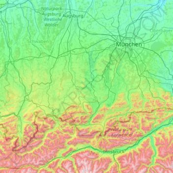
Name: Weilheim-Schongau topographic map, elevation, terrain.
Location: Weilheim-Schongau, Bavaria, 82380, Germany (47.09079 10.36316 48.49079 11.76316)
Average elevation: 936 m
Minimum elevation: 407 m
Maximum elevation: 3,193 m
Other topographic maps
Click on a map to view its topography, its elevation and its terrain.
Passau
On 2 June 2013, the old town suffered from severe flooding as a result of several days of rain and its location at the confluence of three rivers. Peak elevations of floods as early as 1501 are displayed on a wall at the Old City Hall. Flood water reaches the base of that wall on average once every 5 years.
Average elevation: 401 m
Wasserburg am Inn
Germany > Bavaria > Landkreis Rosenheim > Wasserburg am Inn
Average elevation: 474 m