
Dinagat Island topographic map
Interactive map
Click on the map to display elevation.
About this map
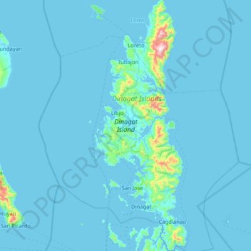
Name: Dinagat Island topographic map, elevation, terrain.
Location: Dinagat Island, Dinagat Islands, Caraga, Philippines (9.85214 125.47344 10.47158 125.70699)
Average elevation: 29 m
Minimum elevation: -1 m
Maximum elevation: 907 m
Other topographic maps
Click on a map to view its topography, its elevation and its terrain.
Dinagat Islands
Dinagat Islands is a young island-province at the northern tip of Mindanao. Many describe Dinagat Islands as a hidden gem of the Caraga Region XIII. The Islands are enriched with great bio-diversity, abundant natural wonders and rich resources. Dinagat Islands has a multitude of fascinating white sandy beaches…
Average elevation: 91 m