
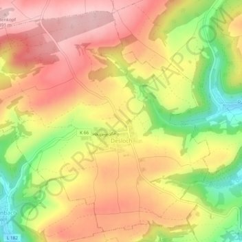
Desloch topographic map
Interactive map
Click on the map to display elevation.
About this map
Name: Desloch topographic map, elevation, terrain.
Average elevation: 300 m
Minimum elevation: 177 m
Maximum elevation: 388 m
Other topographic maps
Click on a map to view its topography, its elevation and its terrain.
Stromberg
Deutschland > Rheinland-Pfalz > Landkreis Bad Kreuznach
Stromberg, Langenlonsheim-Stromberg, Landkreis Bad Kreuznach, Rheinland-Pfalz, 55442, Deutschland
Average elevation: 325 m
Langenthal
Deutschland > Rheinland-Pfalz > Landkreis Bad Kreuznach
Langenthal, Nahe-Glan, Landkreis Bad Kreuznach, Rheinland-Pfalz, Deutschland
Average elevation: 319 m
Rüdesheim
Deutschland > Rheinland-Pfalz > Landkreis Bad Kreuznach
Rüdesheim, Landkreis Bad Kreuznach, Rheinland-Pfalz, 55593, Deutschland
Average elevation: 165 m