
Stromberg topographic map
Interactive map
Click on the map to display elevation.
About this map
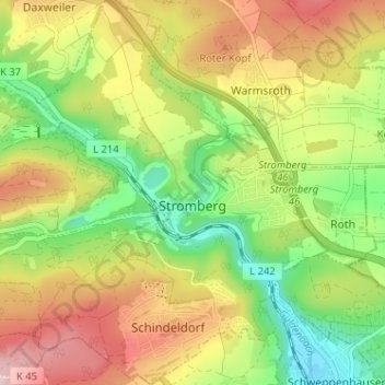
Name: Stromberg topographic map, elevation, terrain.
Average elevation: 325 m
Minimum elevation: 191 m
Maximum elevation: 483 m
Topographisch hat Stromberg ein markantes Profil als „Drei-Täler-Stadt“ am Zusammenfluss von Welschbach und Dörrebach (Lehnbach) mit dem Guldenbach, wobei dieser, der stärkste, die Stromberger Gemarkung etwa halbiert.
Other topographic maps
Click on a map to view its topography, its elevation and its terrain.
Desloch
Deutschland > Rheinland-Pfalz > Landkreis Bad Kreuznach
Desloch, Nahe-Glan, Landkreis Bad Kreuznach, Rheinland-Pfalz, Deutschland
Average elevation: 300 m
Langenthal
Deutschland > Rheinland-Pfalz > Landkreis Bad Kreuznach
Langenthal, Nahe-Glan, Landkreis Bad Kreuznach, Rheinland-Pfalz, Deutschland
Average elevation: 319 m
Rüdesheim
Deutschland > Rheinland-Pfalz > Landkreis Bad Kreuznach
Rüdesheim, Landkreis Bad Kreuznach, Rheinland-Pfalz, 55593, Deutschland
Average elevation: 165 m