
Bühlow topographic map
Interactive map
Click on the map to display elevation.
About this map
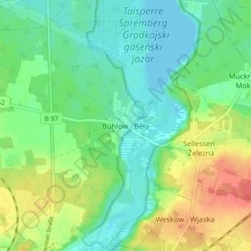
Name: Bühlow topographic map, elevation, terrain.
Average elevation: 109 m
Minimum elevation: 91 m
Maximum elevation: 142 m
Other topographic maps
Click on a map to view its topography, its elevation and its terrain.
Haidemühl
Deutschland > Brandenburg > Spree-Neiße > Spremberg
Haidemühl, Spremberg, Spree-Neiße, Brandenburg, 03130, Deutschland
Average elevation: 115 m
Lieskau
Deutschland > Brandenburg > Spree-Neiße > Spremberg > Lieskau
Lieskau, Spremberg, Spree-Neiße, Brandenburg, 02959, Deutschland
Average elevation: 142 m
Weskow
Deutschland > Brandenburg > Spree-Neiße > Spremberg > Weskow
Weskow, Spremberg, Spree-Neiße, Brandenburg, 03130, Deutschland
Average elevation: 118 m
Obertrattendorf - Górna Dubrawa
Deutschland > Brandenburg > Spree-Neiße > Spremberg
Obertrattendorf - Górna Dubrawa, Spremberg, Spree-Neiße, Brandenburg, Deutschland
Average elevation: 116 m