
坝卡 topographic map
Interactive map
Click on the map to display elevation.
About this map
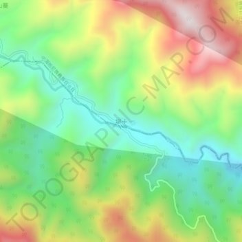
Name: 坝卡 topographic map, elevation, terrain.
Location: 坝卡, 宁洱哈尼族彝族自治县, 普洱市, 云南省, 665000, 中国 (22.69209 101.51791 22.73209 101.55791)
Average elevation: 1,286 m
Minimum elevation: 967 m
Maximum elevation: 1,756 m
Other topographic maps
Click on a map to view its topography, its elevation and its terrain.
东洱河水库
中国 > 云南省 > 宁洱哈尼族彝族自治县 > 宁洱县
东洱河水库, 宁洱县, 宁洱哈尼族彝族自治县, 普洱市, 云南省, 665000, 中国
Average elevation: 1,379 m