
The Summit topographic map
Interactive map
Click on the map to display elevation.
About this map
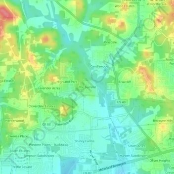
Name: The Summit topographic map, elevation, terrain.
Average elevation: 69 m
Minimum elevation: 43 m
Maximum elevation: 121 m
Other topographic maps
Click on a map to view its topography, its elevation and its terrain.
Northbrook
United States > Alabama > Tuscaloosa County > Northport
Northbrook, Northport, Tuscaloosa County, Alabama, 35476, United States
Average elevation: 70 m
Northport
United States > Alabama > Tuscaloosa County > Northport
Northport, Tuscaloosa County, Alabama, United States
Average elevation: 82 m
Clear Creek Colony
United States > Alabama > Tuscaloosa County > Northport > Clear Creek Colony
Clear Creek Colony, Northport, Tuscaloosa County, Alabama, 35473, United States
Average elevation: 93 m