
Thank you for supporting this site ❤️
Make a donation
Make a donation
Northport topographic map
Click on the map to display elevation.
Thank you for supporting this site ❤️
Make a donation
Make a donation
About this map
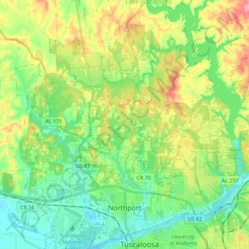
Name: Northport topographic map, elevation, terrain.
Location: Northport, Tuscaloosa County, Alabama, United States (33.20685 -87.67788 33.33824 -87.54223)
Average elevation: 82 m
Minimum elevation: 33 m
Maximum elevation: 166 m
Thank you for supporting this site ❤️
Make a donation
Make a donation
Other topographic maps
Click on a map to view its topography, its elevation and its terrain.
Thank you for supporting this site ❤️
Make a donation
Make a donation
Thank you for supporting this site ❤️
Make a donation
Make a donation
Thank you for supporting this site ❤️
Make a donation
Make a donation
East Lake
United States > Alabama > Tuscaloosa County > Tuscaloosa > East Lake
Average elevation: 110 m
Thank you for supporting this site ❤️
Make a donation
Make a donation