Geolocate

Kintore topographic map

Interactive map

Click on the map to display elevation.

About this map

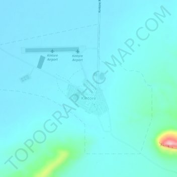
Name: Kintore topographic map, elevation, terrain.

Location: Kintore, Macdonnell Region, Northern Territory, Australia (-23.28889 129.35928 -23.25850 129.40432)

Average elevation: 470 m

Minimum elevation: 447 m

Maximum elevation: 683 m

Other topographic maps

Click on a map to view its topography, its elevation and its terrain.

Yarra Park

Australia > Victoria > Melbourne

Average elevation: 22 m

Crystal Cascades

Australia > Queensland

Average elevation: 365 m

Gladstone

Australia > Queensland

Average elevation: 24 m

Mount Meharry

Australia > Western Australia

The summit of Mt Meharry can be reached from the Great Northern Highway via an unsealed road 16 km (9.9 mi) in length and a vehicular track 21 kilometres (13 mi) in length. Permission should be sought from the managers of the land over which the road and track pass. These are Juna Downs Station and the…

Average elevation: 1,030 m

Mount Bogong

Australia > Victoria

The Big River separates the massif of the mountain from the Bogong High Plains to the south. From the nearby town of Mount Beauty to its summit, Mount Bogong rises more than 1,600 metres (5,200 ft),[citation needed] thus making it one of the highest peaks in Australia not only in terms of its elevation above…

Average elevation: 1,719 m

Bundaberg

Australia > Queensland > Bundaberg Region

Average elevation: 18 m

Joondalup

Australia > Western Australia > Joondalup

Average elevation: 33 m

Sydney

Australia > New South Wales > Sydney

The Hills district generally refers to the suburbs in north-western Sydney including the local government areas of The Hills Shire, parts of the City of Parramatta Council and Hornsby Shire. Actual suburbs and localities that are considered to be in the Hills District can be somewhat amorphous and variable.…

Average elevation: 34 m

Peachester

Australia > Queensland > Peachester

Average elevation: 137 m

Palmerston

Australia > Northern Territory > Palmerston

Average elevation: 25 m

Proserpine

Australia > Queensland > Proserpine

Average elevation: 13 m

Geraldton

Australia > Western Australia > Geraldton

Average elevation: 33 m

Nambung

Australia > Western Australia

Average elevation: 50 m

Townsville

Australia > Queensland > Townsville

Average elevation: 30 m

Rockhampton

Australia > Queensland > Rockhampton

Average elevation: 48 m

Dunsborough

Australia > Western Australia > Dunsborough

Average elevation: 38 m

Gold Coast

Australia > Queensland > Gold Coast

Average elevation: 42 m

Mutitjulu

Australia > Northern Territory > Mutitjulu

Average elevation: 532 m