
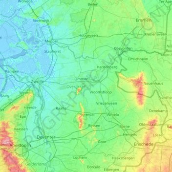
Overijssel topographic map
Interactive map
Click on the map to display elevation.
About this map
Name: Overijssel topographic map, elevation, terrain.
Location: Overijssel, Nederland (52.11807 5.77775 52.85421 7.07276)
Average elevation: 15 m
Minimum elevation: -5 m
Maximum elevation: 109 m
Other topographic maps
Click on a map to view its topography, its elevation and its terrain.
Voorthuizen
Voorthuizen, Barneveld, Gelderland, Nederland
Average elevation: 15 m
Harderwijk
Nederland > Gelderland > Harderwijk
Harderwijk, Gelderland, Nederland
Average elevation: 7 m
Alphen aan den Rijn
Alphen aan den Rijn, Zuid-Holland, Nederland
Average elevation: -2 m
Gorinchem
Nederland > Zuid-Holland > Gorinchem
Gorinchem, Zuid-Holland, Nederland
Average elevation: 1 m
Utrechtse Heuvelrug
Utrechtse Heuvelrug, Utrecht, Nederland
Average elevation: 10 m
Noordwijk
Nederland > Zuid-Holland > Noordwijk
Noordwijk, Zuid-Holland, Nederland
Average elevation: 1 m
Bergen
Nederland > Noord-Holland > Bergen
Bergen, Noord-Holland, Nederland, 1861KB, Nederland
Average elevation: 3 m
Geldrop
Geldrop, Geldrop-Mierlo, Noord-Brabant, Nederland
Average elevation: 21 m