
Argeș topographic map
Interactive map
Click on the map to display elevation.
About this map
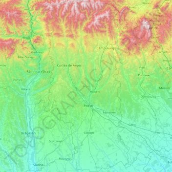
Name: Argeș topographic map, elevation, terrain.
Location: Argeș, Romania (44.37686 24.42151 45.61120 25.32598)
Average elevation: 572 m
Minimum elevation: 90 m
Maximum elevation: 2,505 m
Other topographic maps
Click on a map to view its topography, its elevation and its terrain.
Mărtinești
Mărtinești, Tureni, Cluj Metropolitan Area, Cluj, 407563, Romania
Average elevation: 585 m
Peana
Romania > Cluj > Cluj-Napoca
Peana, Cluj-Napoca, Cluj Metropolitan Area, Cluj, 407271, Romania
Average elevation: 741 m
Dorolea
Dorolea, Livezile, Bistrița-Năsăud, 427122, Romania
Average elevation: 488 m
Carpathian Mountains
Carpathian Mountains, Toplița, Harghita, 535705, Romania
Average elevation: 980 m