
Thank you for supporting this site ❤️
Make a donation
Make a donation
Pristol topographic map
Click on the map to display elevation.
Thank you for supporting this site ❤️
Make a donation
Make a donation
About this map
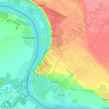
Name: Pristol topographic map, elevation, terrain.
Location: Pristol, Mehedinți, Romania (44.20304 22.67210 44.29755 22.77846)
Average elevation: 65 m
Minimum elevation: 31 m
Maximum elevation: 116 m
Thank you for supporting this site ❤️
Make a donation
Make a donation
Other topographic maps
Click on a map to view its topography, its elevation and its terrain.
Thank you for supporting this site ❤️
Make a donation
Make a donation
Thank you for supporting this site ❤️
Make a donation
Make a donation
Thank you for supporting this site ❤️
Make a donation
Make a donation