
Sonsbeek topographic map
Interactive map
Click on the map to display elevation.
About this map
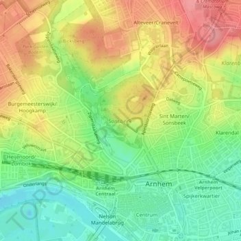
Name: Sonsbeek topographic map, elevation, terrain.
Location: Sonsbeek, Arnhem, Güeldres, Países Bajos (51.98607 5.89660 51.99660 5.91030)
Average elevation: 43 m
Minimum elevation: -2 m
Maximum elevation: 90 m
Other topographic maps
Click on a map to view its topography, its elevation and its terrain.
Praets
Países Bajos > Güeldres > Arnhem > Praets
Praets, Arnhem, Güeldres, Países Bajos, 6841, Países Bajos
Average elevation: 25 m