
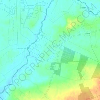
Pollaphuca topographic map
Interactive map
Click on the map to display elevation.
About this map
Name: Pollaphuca topographic map, elevation, terrain.
Average elevation: 63 m
Minimum elevation: 52 m
Maximum elevation: 89 m
Other topographic maps
Click on a map to view its topography, its elevation and its terrain.
Balgriffin
Balgriffin, Balgriffin ED, Fingal, County Dublin, Leinster, Ireland
Average elevation: 26 m
Tullyallen
Tullyallen, St. Peter's ED, The Borough District of Drogheda, County Louth, Leinster, Ireland
Average elevation: 49 m
Donard
Donard, Donard ED, The Municipal District of Baltinglass, County Wicklow, Leinster, W91 TW42, Ireland
Average elevation: 212 m
Lucan
Lucan, South Dublin, County Dublin, Leinster, K78 Y0F1, Ireland
Average elevation: 59 m
Blanchardstown
Blanchardstown, Fingal, County Dublin, Leinster, D15 KPW7, Ireland
Average elevation: 61 m
Garadice
Garadice, Gallow ED, The Municipal District of Trim, County Meath, Leinster, Ireland
Average elevation: 111 m
Westmanstown
Westmanstown, Lucan North DED 1986, Fingal, County Dublin, Leinster, Ireland
Average elevation: 54 m
Stranorlar
Stranorlar, Lifford-Stranorlar Municipal District, County Donegal, F93 HY64, Ireland
Average elevation: 92 m
Ballina
Ballina, Ballina Municipal District, County Mayo, Connacht, Ireland
Average elevation: 19 m
Thurles
Thurles, The Municipal District of Thurles, County Tipperary, Munster, Ireland
Average elevation: 101 m
Dungarvan
Dungarvan, The Municipal District of Dungarvan — Lismore, County Waterford, Munster, X35 V670, Ireland
Average elevation: 30 m
Waterford
Waterford, County Waterford, Munster, Ireland
Average elevation: 33 m
Ennis Municipal District
Ennis Municipal District, County Clare, Munster, Ireland
Average elevation: 39 m
Galway City
Galway City, County Galway, Connacht, Ireland
Average elevation: 16 m
Dún Laoghaire
Ireland > County Dublin > Dún Laoghaire
Dún Laoghaire, Dún Laoghaire-Rathdown, County Dublin, Leinster, A96 A258, Ireland
Average elevation: 21 m
Killarney Municipal District
Killarney Municipal District, County Kerry, Munster, Ireland
Average elevation: 191 m
Tibradden ED
Tibradden ED, Dublin 16, Dún Laoghaire-Rathdown, County Dublin, Leinster, Ireland
Average elevation: 236 m
Ferns Upper
Ferns Upper, Ferns, County Wexford, Leinster, Ireland
Average elevation: 59 m
Lugnaquilla
Lugnaquilla, The Municipal District of Baltinglass, County Wicklow, Leinster, Ireland
Average elevation: 697 m
Wicklow Mountains National Park
Wicklow Mountains National Park, Mullaghcleevaun to Moanbane and Silsean, Glenbride, Lackan, The Municipal District of Baltinglass, County Wicklow, Leinster, Ireland
Average elevation: 324 m
Cherry Orchard
Cherry Orchard, Merchants Quay E ED, Dublin 8, Dublin, County Dublin, Leinster, Ireland
Average elevation: 25 m
Carrauntoohil
Carrauntoohil, Kenmare Municipal District, County Kerry, Munster, V93 A8N1, Ireland
Average elevation: 643 m