
County Kerry topographic map
Click on the map to display elevation.
County Kerry
Bounded by the Atlantic Ocean, Kerry is Ireland's most westerly county. Its rugged coastline stretches for 886 kilometres (551 miles) and is characterised by bays, sea cliffs, beaches and many small offshore islands, of which the Blaskets and the Skelligs are the most notable. The county's peninsulas have a hilly to mountainous topography, with the MacGillycuddy's Reeks on Iveragh rising to over 1,000 m (3,300 ft). By contrast, its interior regions are mostly flat, interspersed with low mountain ranges such as the Stacks and the Mullaghareirks. The climate of Kerry is dominated by the North Atlantic Current and is usually mild and humid, with abundant precipitation. This allows for the growth of a wide variety of temperate and sub-tropical plants not typically found at such northerly latitudes.
About this map
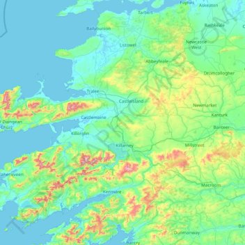
Name: County Kerry topographic map, elevation, terrain.
Location: County Kerry, Munster, Ireland (51.68820 -10.66262 52.60245 -9.11875)
Average elevation: 123 m
Minimum elevation: -2 m
Maximum elevation: 971 m
Other topographic maps
Click on a map to view its topography, its elevation and its terrain.
Blanchardstown
Blanchardstown was a predominantly rural area, with a small village, in western County Dublin, alongside the neighbouring district of Castleknock. Both areas shared a common history until well into the 19th century, when their development diverged. In A Topographical Dictionary of Ireland, published in 1837,…
Average elevation: 61 m