
Fountain Hill topographic map
Interactive map
Click on the map to display elevation.
About this map
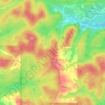
Name: Fountain Hill topographic map, elevation, terrain.
Location: Fountain Hill, Bibb County, Alabama, United States (33.15729 -87.08116 33.15739 -87.08106)
Average elevation: 166 m
Minimum elevation: 113 m
Maximum elevation: 205 m
Other topographic maps
Click on a map to view its topography, its elevation and its terrain.
East Centreville
United States > Alabama > Bibb County > Centreville
East Centreville, Centreville, Bibb County, Alabama, 35042, United States
Average elevation: 77 m
Lawley
United States > Alabama > Bibb County
Lawley, Bibb County, Alabama, 35793, United States
Average elevation: 139 m
Centreville
United States > Alabama > Bibb County
Centreville, Bibb County, Alabama, 35042, United States
Average elevation: 93 m
Tucker
United States > Alabama > Bibb County > Tucker
Tucker, Bibb County, Alabama, United States
Average elevation: 150 m
Randolph
United States > Alabama > Bibb County > Randolph
Randolph, Bibb County, Alabama, United States
Average elevation: 162 m
Schultz Creek
United States > Alabama > Bibb County
Schultz Creek, Bibb County, Alabama, United States
Average elevation: 115 m
Sand Mountain
United States > Alabama > Bibb County
Sand Mountain, Bibb County, Alabama, United States
Average elevation: 156 m
Brent
United States > Alabama > Bibb County > Brent
Brent, Bibb County, Alabama, 35034, United States
Average elevation: 84 m