Geolocate

Lawley topographic map

Interactive map

Click on the map to display elevation.

About this map

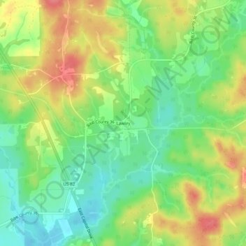
Name: Lawley topographic map, elevation, terrain.

Location: Lawley, Bibb County, Alabama, 35793, United States (32.83957 -86.97138 32.87957 -86.93138)

Average elevation: 139 m

Minimum elevation: 107 m

Maximum elevation: 178 m

Other topographic maps

Click on a map to view its topography, its elevation and its terrain.

East Centreville

United States > Alabama > Bibb County > Centreville

East Centreville, Centreville, Bibb County, Alabama, 35042, United States

Average elevation: 77 m

Fountain Hill

United States > Alabama > Bibb County

Fountain Hill, Bibb County, Alabama, United States

Average elevation: 166 m

Centreville

United States > Alabama > Bibb County

Centreville, Bibb County, Alabama, 35042, United States

Average elevation: 93 m

Tucker

United States > Alabama > Bibb County > Tucker

Tucker, Bibb County, Alabama, United States

Average elevation: 150 m

Randolph

United States > Alabama > Bibb County > Randolph

Randolph, Bibb County, Alabama, United States

Average elevation: 162 m

Schultz Creek

United States > Alabama > Bibb County

Schultz Creek, Bibb County, Alabama, United States

Average elevation: 115 m

Sand Mountain

United States > Alabama > Bibb County

Sand Mountain, Bibb County, Alabama, United States

Average elevation: 156 m

Brent

United States > Alabama > Bibb County > Brent

Brent, Bibb County, Alabama, 35034, United States

Average elevation: 84 m