
Aoral topographic map
Interactive map
Click on the map to display elevation.
About this map
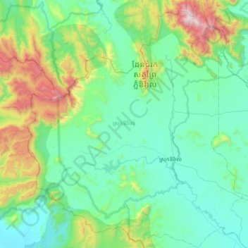
Name: Aoral topographic map, elevation, terrain.
Location: Aoral, Kampong Speu, Cambodia (11.47980 103.77298 12.07685 104.30386)
Average elevation: 342 m
Minimum elevation: 15 m
Maximum elevation: 1,789 m
Other topographic maps
Click on a map to view its topography, its elevation and its terrain.
Chhreav Waterfall
Cambodia > Kampong Speu > Aoral
Chhreav Waterfall, Aoral, Kampong Speu, Cambodia
Average elevation: 408 m