Geolocate

南天湖镇 topographic map

Interactive map

Click on the map to display elevation.

About this map

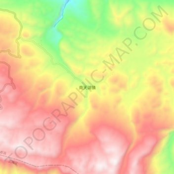
Name: 南天湖镇 topographic map, elevation, terrain.

Location: 南天湖镇, 丰都县, 渝东北三峡库区城镇群区位, 重庆市, 中国 (29.66059 107.88046 29.74059 107.96046)

Average elevation: 1,328 m

Minimum elevation: 634 m

Maximum elevation: 1,829 m

Other topographic maps

Click on a map to view its topography, its elevation and its terrain.

丰都双桂山国家森林公园

中国 > 重庆市 > 丰都县 > 名山街道

丰都双桂山国家森林公园, 名山街道, 丰都县, 重庆市, 中国

Average elevation: 266 m

龙河镇

中国 > 重庆市 > 丰都县

龙河镇, 丰都县, 重庆市, 中国

Average elevation: 662 m

太平坝乡

中国 > 重庆市 > 丰都县

太平坝乡, 丰都县, 渝东北三峡库区城镇群, 重庆市, 中国

Average elevation: 1,613 m

丰都县

中国 > 重庆市 > 丰都县

丰都县, 渝东北三峡库区城镇群区位, 重庆市, 中国

Average elevation: 538 m

武平镇

中国 > 重庆市 > 丰都县

武平镇, 丰都县, 渝东北三峡库区城镇群区位, 重庆市, 中国

Average elevation: 1,325 m

龙孔镇

中国 > 重庆市 > 丰都县

龙孔镇, 丰都县, 渝东北三峡库区城镇群区位, 重庆市, 中国

Average elevation: 432 m