
Make a donation
Peñas topographic map
Click on the map to display elevation.
Make a donation
About this map
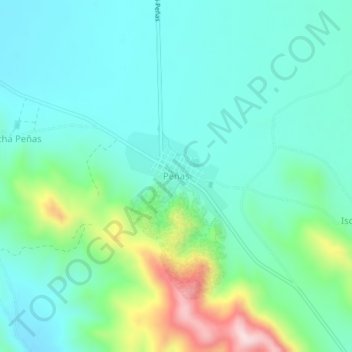
Name: Peñas topographic map, elevation, terrain.
Location: Peñas, Batallas, Provincia Los Andes, La Paz, Bolivia (-16.25198 -68.52395 -16.21198 -68.48395)
Average elevation: 4,023 m
Minimum elevation: 3,929 m
Maximum elevation: 4,330 m
Make a donation
Other topographic maps
Click on a map to view its topography, its elevation and its terrain.
Pucarani
Bolivia > La Paz > Provincia Los Andes
Se encuentra ubicado a 30 km de la ciudad de La Paz, capital del departamento, a una altitud de 3.865 metros sobre el nivel del mar. Según el censo nacional de 2012, el municipio de Pucarani contaba con una población de 29.379 habitantes, a la actualidad, el Censo 2024 estableció una población de 49.701…
Average elevation: 4,050 m
Make a donation
Batallas
Bolivia > La Paz > Provincia Los Andes
El municipio se encuentra a una altitud promedio de 3.900 m s. n. m., ubicado al sureste del Lago Titicaca en Bolivia, en la región del Altiplano de los Andes, entre la Cordillera Occidental en el oeste y la Cordillera Central en el este. La región tiene un clima diurno en donde las variaciones de…
Average elevation: 4,096 m
Puerto Perez
Bolivia > La Paz > Provincia Los Andes > Municipio Puerto Pérez
Average elevation: 3,822 m
Make a donation
Corqueamaya
Bolivia > La Paz > Provincia Los Andes > Batallas > Corqueamaya
Average elevation: 3,967 m
Pucarani
Bolivia > La Paz > Provincia Los Andes
Se encuentra ubicado a 30 km de la ciudad de La Paz, capital del departamento, a una altitud de 3865 metros sobre el nivel del mar. Según el censo nacional de 2012, el municipio de Pucarani contaba con una población de 29 379 habitantes, a la actualidad, el censo de 2024 estableció una población de 49 701…
Average elevation: 4,050 m