
Thank you for supporting this site ❤️
Make a donation
Make a donation
Cold Bay topographic map
Click on the map to display elevation.
Thank you for supporting this site ❤️
Make a donation
Make a donation
About this map
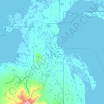
Name: Cold Bay topographic map, elevation, terrain.
Location: Cold Bay, Aleutians East, Alaska, 99571, United States (55.11901 -162.92878 55.28067 -162.56910)
Average elevation: 62 m
Minimum elevation: -2 m
Maximum elevation: 1,225 m
Thank you for supporting this site ❤️
Make a donation
Make a donation
Other topographic maps
Click on a map to view its topography, its elevation and its terrain.
Thank you for supporting this site ❤️
Make a donation
Make a donation
Unga
United States > Alaska > Aleutians East
55°11′03″N 160°30′18″W / 55.18417°N 160.50500°W / 55.18417; -160.50500 Unga (Unangam tunuu: Uĝnaasaqax̂) is a ghost town on Unga Island in the Aleutians East Borough of the U.S. state of Alaska, about two miles west of Sand Point. The island's length is 15 miles (24 km). Unga's altitude is 59 feet (18 m).
Average elevation: 56 m
Thank you for supporting this site ❤️
Make a donation
Make a donation