
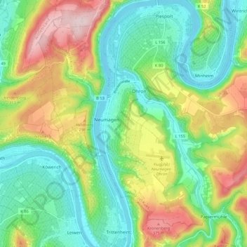
Neumagen-Dhron topographic map
Interactive map
Click on the map to display elevation.
About this map
Name: Neumagen-Dhron topographic map, elevation, terrain.
Average elevation: 218 m
Minimum elevation: 108 m
Maximum elevation: 418 m
Die Gemeinde besteht aus den drei Ortsteilen Neumagen, Dhron und Papiermühle. Zur Gemeinde gehören auch die Wohnplätze Leienhaus, Luymühle, Unterste Mühle, Auf der Leienkaul, Hof Kron, Hof Weißhaus, Karmelerhof, Nuhkopf, Schneidershof, Konstantinshöhe.
Other topographic maps
Click on a map to view its topography, its elevation and its terrain.
Papiermühle
Deutschland > Rheinland-Pfalz > Landkreis Bernkastel-Wittlich > Neumagen-Dhron
Papiermühle, Neumagen-Dhron, Bernkastel-Kues, Landkreis Bernkastel-Wittlich, Rheinland-Pfalz, Deutschland
Average elevation: 296 m